IMAGES TAKEN NEAR TO
Bryngwran, HOLYHEAD, LL65 3SH
Introduction
This page details the photographs taken nearby to LL65 3SH by members of the Geograph project.
The Geograph project started in 2005 with the aim of publishing, organising and preserving representative images for every square kilometre of Great Britain, Ireland and the Isle of Man.

There are currently over 7.5m images from over14,400 individuals and you can help contribute to the project by visiting https://www.geograph.org.uk
Image Map
Images are licensed for reuse under creativecommons.org/licenses/by-sa/2.0
Notes
- Clicking on the map will re-center to the selected point.
- The higher the marker number, the further away the image location is from the centre of the postcode.
Image Listing (18 Images Found)
Images are licensed for reuse under creativecommons.org/licenses/by-sa/2.0
Image
Details
Distance
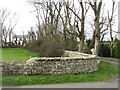
1
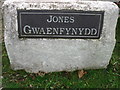
Entrance stone for Gwaenfynydd House
What happens when Mr Jones wants to sell, and the buyer is not called Jones?
Image: © David Purchase
Taken: 13 Dec 2019
0.03 miles

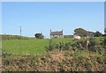
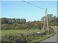
8
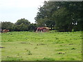
View across farmlands towards Ty Croes farmhouse
Image: © Eric Jones
Taken: 3 Nov 2008
0.10 miles
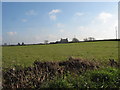
9
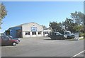
Bend in the road south of Bryn Glas Garage
Image: © Eric Jones
Taken: 23 Sep 2008
0.10 miles