IMAGES TAKEN NEAR TO
Bryngwran, HOLYHEAD, LL65 3RW
Introduction
This page details the photographs taken nearby to LL65 3RW by members of the Geograph project.
The Geograph project started in 2005 with the aim of publishing, organising and preserving representative images for every square kilometre of Great Britain, Ireland and the Isle of Man.

There are currently over 7.5m images from over14,400 individuals and you can help contribute to the project by visiting https://www.geograph.org.uk
Image Map
Images are licensed for reuse under creativecommons.org/licenses/by-sa/2.0
Notes
- Clicking on the map will re-center to the selected point.
- The higher the marker number, the further away the image location is from the centre of the postcode.
Image Listing (22 Images Found)
Images are licensed for reuse under creativecommons.org/licenses/by-sa/2.0
Image
Details
Distance
1
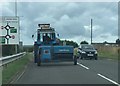
Tractor and Baler on the A4080
Approaching the A55 North Wales Expressway
Image: © Eirian Evans
Taken: 12 Aug 2019
0.00 miles
3
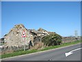
Roofless barn between Engedi and Bwlcyn Farm
Image: © Eric Jones
Taken: 23 Sep 2008
0.04 miles
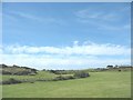
4
Bwlcyn Farm
Bwlcyn Farm stands at the southern end of the Engedi bridge.
Image: © Eric Jones
Taken: 23 Sep 2008
0.05 miles
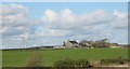
6
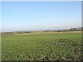
View across farmland and a (hidden) expressway interchange to Bwlcyn farmhouse
Image: © Eric Jones
Taken: 4 Jul 2008
0.08 miles
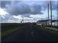
7
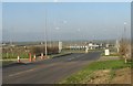
Traffic roundabout on the south side of Engedi bridge
Image: © Eric Jones
Taken: 3 Nov 2008
0.09 miles
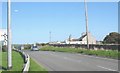
8
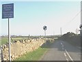
Narrow road westwards from the Engedi crossroads
Image: © Eric Jones
Taken: 3 Nov 2008
0.10 miles
10
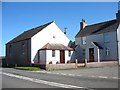
Capel a Ty Capel Engedi
Engedi, a Calvinistic Methodist chapel, built in 1881 has given its name to this small hamlet west of the A 55. The chapel remains open.
Image: © Eric Jones
Taken: 23 Sep 2008
0.11 miles