IMAGES TAKEN NEAR TO
Bryngwran, HOLYHEAD, LL65 3RG
Introduction
This page details the photographs taken nearby to LL65 3RG by members of the Geograph project.
The Geograph project started in 2005 with the aim of publishing, organising and preserving representative images for every square kilometre of Great Britain, Ireland and the Isle of Man.

There are currently over 7.5m images from over14,400 individuals and you can help contribute to the project by visiting https://www.geograph.org.uk
Image Map
Images are licensed for reuse under creativecommons.org/licenses/by-sa/2.0
Notes
- Clicking on the map will re-center to the selected point.
- The higher the marker number, the further away the image location is from the centre of the postcode.
Image Listing (5 Images Found)
Images are licensed for reuse under creativecommons.org/licenses/by-sa/2.0
Image
Details
Distance
1
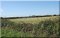
View across a hayfield to Rhyd-yr-wyn cottage
Rhyd-yr-wyn means "ford of the lambs".
Image: © Eric Jones
Taken: 23 Sep 2008
0.07 miles
2
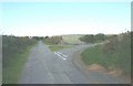
Road junction south of Parc
The image is taken from the direction of the A5.
Image: © Eric Jones
Taken: 23 Sep 2008
0.15 miles
3
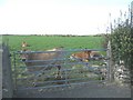
Jersey cows at a field gate south of Rhyd-yr-wyn
Image: © Eric Jones
Taken: 23 Sep 2008
0.18 miles
4
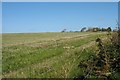
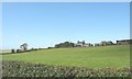
Harvested hayfield south of Parc farmhouse
The farmhouse can be seen in the clump of trees on the skyline right.
Image: © Eric Jones
Taken: 23 Sep 2008
0.19 miles
5
Parc Farm
Parc Farm is situated in a sparsely populated area where the settlement pattern is dominated by large pastoral farms.
Image: © Eric Jones
Taken: 23 Sep 2008
0.22 miles