IMAGES TAKEN NEAR TO
Valley, HOLYHEAD, LL65 3HA
Introduction
This page details the photographs taken nearby to LL65 3HA by members of the Geograph project.
The Geograph project started in 2005 with the aim of publishing, organising and preserving representative images for every square kilometre of Great Britain, Ireland and the Isle of Man.

There are currently over 7.5m images from over14,400 individuals and you can help contribute to the project by visiting https://www.geograph.org.uk
Image Map
Images are licensed for reuse under creativecommons.org/licenses/by-sa/2.0
Notes
- Clicking on the map will re-center to the selected point.
- The higher the marker number, the further away the image location is from the centre of the postcode.
Image Listing (22 Images Found)
Images are licensed for reuse under creativecommons.org/licenses/by-sa/2.0
Image
Details
Distance
1
Heading south-east on the Wales Coast Path
Shortly after leaving Four Mile Bridge
Image: © Eirian Evans
Taken: 12 Aug 2019
0.09 miles
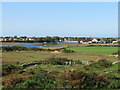
2
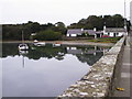
Four Mile Bridge
This is the bridge across the strait separating the main island of Anglesey from Holy Island on the B4545 between Valley and Trearddur Bay.
Image: © alan smethurst
Taken: 24 Sep 2002
0.10 miles
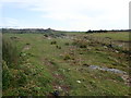
3
Saltmarsh near Four Mile Bridge
Saltmarsh along the edge of Cymyran Strait. Bungalows at Four Mile Bridge in the background.
Image: © Gordon Hatton
Taken: 20 Sep 2020
0.12 miles
4
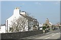
Cottages on the Anglesey side of the Four Mile Bridge
Image: © Eric Jones
Taken: 8 Aug 2007
0.16 miles
5
Cottages at the Anglesey end of the Four Mile Bridge
Image: © Eric Jones
Taken: 7 May 2008
0.16 miles
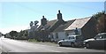
6
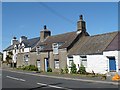
Cottages, Four Mile Bridge
On the B4545 from Valley just before the bridge.
Image: © Robin Drayton
Taken: 20 Jun 2008
0.19 miles
7
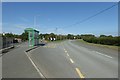
Bus stop on the B4545
A bus stop between Pont Rhydbont and the A55.
Image: © DS Pugh
Taken: 5 Aug 2018
0.19 miles
8
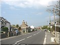
Entering Y Fali/Valley on the B4545
"Y Fali" is a transcription of the English "Valley". From time to time, pedants have sought to render Y Fali as "Dyffryn", a Welsh word meaning "valley". But this is to misunderstand the way the village's name came about - there is no valley (at least in the traditional Welsh sense) in Valley - the Fali was a huge cutting made in the area by Telford in order to get soil and rock to build the Stanley Embankment which would take his road across the Inland Sea to Holyhead.
Image: © Eric Jones
Taken: 7 May 2008
0.19 miles
9
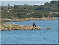
Fisherman near Pont Rhydbont / Four Mile Bridge
Image: © Mat Fascione
Taken: 4 Aug 2011
0.20 miles
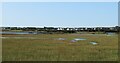
10
Fields and saltmarsh towards Four Mile Bridge
A view looking west from the Anglesey Coast Path. Areas of pasture and thorn bushes mixed with saltmarsh in the foreground with Four Mile Bridge in the distance.
Image: © Gordon Hatton
Taken: 20 Sep 2020
0.20 miles