IMAGES TAKEN NEAR TO
Caergeiliog, HOLYHEAD, LL65 3EZ
Introduction
This page details the photographs taken nearby to LL65 3EZ by members of the Geograph project.
The Geograph project started in 2005 with the aim of publishing, organising and preserving representative images for every square kilometre of Great Britain, Ireland and the Isle of Man.

There are currently over 7.5m images from over14,400 individuals and you can help contribute to the project by visiting https://www.geograph.org.uk
Image Map
Images are licensed for reuse under creativecommons.org/licenses/by-sa/2.0
Notes
- Clicking on the map will re-center to the selected point.
- The higher the marker number, the further away the image location is from the centre of the postcode.
Image Listing (17 Images Found)
Images are licensed for reuse under creativecommons.org/licenses/by-sa/2.0
Image
Details
Distance
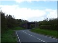
2
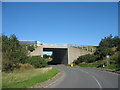
Bridge carrying the A 55 over a minor road which links with the A 5
Image: © Eric Jones
Taken: 23 Sep 2008
0.06 miles
3
New section of road leading northwards beneath the A55 to join the A5
Image: © Eric Jones
Taken: 23 Sep 2008
0.06 miles
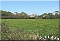
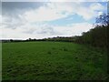
4
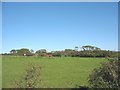
View northwards across farmland towards Cymunod
Image: © Eric Jones
Taken: 23 Sep 2008
0.06 miles
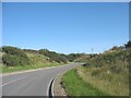
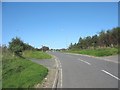
5
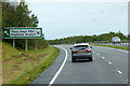
North Wales Expressway near Anglesey Airport
Image: © David Dixon
Taken: 24 Sep 2017
0.08 miles
6
A55 North Wales Expressway bridge over minor road
Image: © JThomas
Taken: 16 Apr 2024
0.10 miles
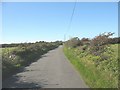
10
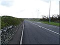
Ffordd Caergybi (Holyhead Road) towards Bryngwran
Image: © JThomas
Taken: 16 Apr 2024
0.16 miles