IMAGES TAKEN NEAR TO
Lon Gardener, HOLYHEAD, LL65 3DN
Introduction
This page details the photographs taken nearby to Lon Gardener, LL65 3DN by members of the Geograph project.
The Geograph project started in 2005 with the aim of publishing, organising and preserving representative images for every square kilometre of Great Britain, Ireland and the Isle of Man.

There are currently over 7.5m images from over14,400 individuals and you can help contribute to the project by visiting https://www.geograph.org.uk
Image Map
Images are licensed for reuse under creativecommons.org/licenses/by-sa/2.0
Notes
- Clicking on the map will re-center to the selected point.
- The higher the marker number, the further away the image location is from the centre of the postcode.
Image Listing (44 Images Found)
Images are licensed for reuse under creativecommons.org/licenses/by-sa/2.0
Image
Details
Distance
1
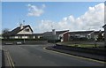
Ffordd Pendyffryn Housing Estate
Valley has seen a major expansion in the last 20-30 years with the building of new housing estates on the outskirts of the village.
Image: © Eric Jones
Taken: 3 May 2009
0.11 miles
2
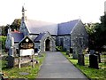
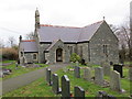
St. Michael's Church - Eglwys Sant Mihangel, Y Fali
St. Michael's Church - Eglwys Sant Mihangel, Y Fali, Isle of Anglesey.
Image: © Arthur C Harris
Taken: 11 Sep 2014
0.13 miles
3
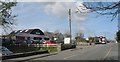
The A5 at Valley
The A5 is now a relatively quiet backwater now that the A55 Expressway takes the bulk of the heavy traffic. Prior to this the A5 was absolute murder.
Image: © Eric Jones
Taken: 3 May 2009
0.14 miles
4
The end of the overhead power line from the Wylfa Atomic Station
From the remainder of its journey to Anglesey Aluminium Image the power is conveyed underground. Anglesey Aluminium accounts for 10% of all Welsh electricity consumption. Even assuming that the company gets a handsome bulk buying discount, I wouldn't like to see their quarterly bill landing on my doormat.
Image: © Eric Jones
Taken: 8 Aug 2007
0.15 miles
5
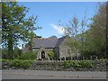
The Church of St Michael at Valley
Viewed from the south-west.
Image: © Peter Wood
Taken: 5 Dec 2017
0.15 miles
6
St Michael/Sant Mihangel, Valley
This church was built in 1867 to serve the growing village of Valley in the southern section of the parish of Llanynghenedl. In time, it took over from the parish church situated in the hamlet of Llanynghenedl. That church was eventually demolished in the 1980s.
Image: © Eric Jones
Taken: 3 May 2009
0.16 miles
7
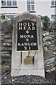
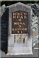
Old Milestone by the A5, Holyhead Road, Valley, Anglesey
Telford Plate by the A5, in parish of Valley (Anglesey District), opposite Valley Hospital, against wall.
Inscription reads:-
HOLY-
HEAD
4
MONA
9
BANGOR
21
Defaced benchmark on lower face.
Grade II listed see Cadw entry https://cadwpublic-api.azurewebsites.net/reports/listedbuilding/FullReport?lang=&id=19232
Milestone Society National ID: ANG_HH04
Image: © Milestone Society
Taken: Unknown
0.16 miles
8
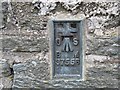
Ordnance Survey Flush Bracket S7556
This bracket can be found on the wall of St Michael's church at Valley. The benchmark height is recorded as being 4.074 metres above sea level. For more detail see : http://www.bench-marks.org.uk/bm16423
Image: © Peter Wood
Taken: 5 Dec 2017
0.16 miles
9
Milestone
Milestone on the A.5 at Valley / Y Fali, Isle of Anglesey for overall view see http://www.geograph.org.uk/photo/5376988
Image: © Keith Evans
Taken: 25 Apr 2017
0.16 miles
10
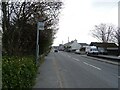
Bus stop on Ffordd Caergybi, Y Fali (Valley)
The A5.
Image: © JThomas
Taken: 16 Apr 2024
0.16 miles