IMAGES TAKEN NEAR TO
Penrodyn, HOLYHEAD, LL65 3BE
Introduction
This page details the photographs taken nearby to Penrodyn, LL65 3BE by members of the Geograph project.
The Geograph project started in 2005 with the aim of publishing, organising and preserving representative images for every square kilometre of Great Britain, Ireland and the Isle of Man.

There are currently over 7.5m images from over14,400 individuals and you can help contribute to the project by visiting https://www.geograph.org.uk
Image Map
Images are licensed for reuse under creativecommons.org/licenses/by-sa/2.0
Notes
- Clicking on the map will re-center to the selected point.
- The higher the marker number, the further away the image location is from the centre of the postcode.
Image Listing (17 Images Found)
Images are licensed for reuse under creativecommons.org/licenses/by-sa/2.0
Image
Details
Distance
5
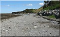
Shingle beach and cliff base protection below the Newlands Park Estate
Image: © Eric Jones
Taken: 8 Aug 2007
0.16 miles
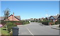
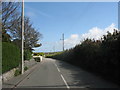
6
Newlands Park
A residential area to the north of Valley on Anglesey
Image: © Eirian Evans
Taken: 18 Jun 2015
0.17 miles
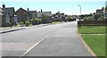
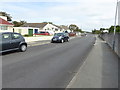
7
The entrance to Parc Newlands, Y Fali
Image: © David Medcalf
Taken: 24 Jul 2014
0.17 miles
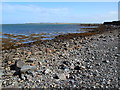
8
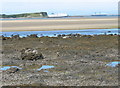
Wave cut platform and rock pools
In the background can be seen the Gorsedd y Penrhyn headland, the Salt Island pier and the Holyhead Breakwater. The ship is one of Stena Lines' ferries.
Image: © Eric Jones
Taken: 8 Aug 2007
0.19 miles