IMAGES TAKEN NEAR TO
Rhoscolyn, HOLYHEAD, LL65 2NQ
Introduction
This page details the photographs taken nearby to LL65 2NQ by members of the Geograph project.
The Geograph project started in 2005 with the aim of publishing, organising and preserving representative images for every square kilometre of Great Britain, Ireland and the Isle of Man.

There are currently over 7.5m images from over14,400 individuals and you can help contribute to the project by visiting https://www.geograph.org.uk
Image Map
Images are licensed for reuse under creativecommons.org/licenses/by-sa/2.0
Notes
- Clicking on the map will re-center to the selected point.
- The higher the marker number, the further away the image location is from the centre of the postcode.
Image Listing (6 Images Found)
Images are licensed for reuse under creativecommons.org/licenses/by-sa/2.0
Image
Details
Distance
1
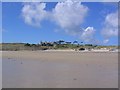
Borthwen
this is the view from the beach at Borthwen looking north west.
Image: © Dave Smethurst
Taken: 19 Aug 2005
0.07 miles
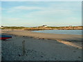
3
Cottages on rock outcrops overlooking the marsh
Image: © Eric Jones
Taken: 7 May 2008
0.22 miles
4
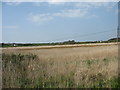
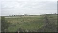
Bay head marsh
This large area of marsh is probably the result of stream deposition into a lagoon formed behind a dune barrier.
Image: © Eric Jones
Taken: 7 May 2008
0.23 miles
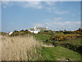
5
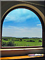
View of Rhoscolyn reed bed/ fields/ beach
Image: © Tony Griffiths
Taken: 24 Jul 2008
0.24 miles