IMAGES TAKEN NEAR TO
Penrhos Feilw, HOLYHEAD, LL65 2LT
Introduction
This page details the photographs taken nearby to LL65 2LT by members of the Geograph project.
The Geograph project started in 2005 with the aim of publishing, organising and preserving representative images for every square kilometre of Great Britain, Ireland and the Isle of Man.

There are currently over 7.5m images from over14,400 individuals and you can help contribute to the project by visiting https://www.geograph.org.uk
Image Map
Images are licensed for reuse under creativecommons.org/licenses/by-sa/2.0
Notes
- Clicking on the map will re-center to the selected point.
- The higher the marker number, the further away the image location is from the centre of the postcode.
Image Listing (22 Images Found)
Images are licensed for reuse under creativecommons.org/licenses/by-sa/2.0
Image
Details
Distance
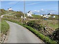
1
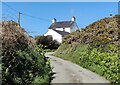
Road leading to Trearddur
Looking along the road from a junction with a no through road.
Image: © DS Pugh
Taken: 5 Aug 2018
0.04 miles
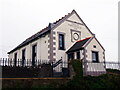
2
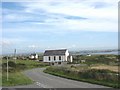
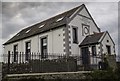
Capel Penrhosfeilw
This chapel was built by the Calvinistic Methodists in the vernacular style in 1895. It closed in 2001 and has been converted into a dwelling.
Image: © Eric Jones
Taken: 21 Jul 2008
0.06 miles
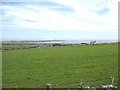
3
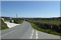
Road to South Stack and Holyhead
Looking along the road from the junction with a no through road leading to the nature reserve.
Image: © DS Pugh
Taken: 5 Aug 2018
0.07 miles
5
Addoldy Penrhos Feilw
Another conversion to a domestic property.
Image: © Chris Andrews
Taken: 3 Jul 2021
0.09 miles
8
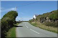
Addoldy Penrhos - Feilw 1895
Apparently now a holiday home.
Image: © Arthur C Harris
Taken: 22 May 2019
0.10 miles
9
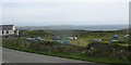
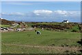
Campsite near the former Capel Penrhosfeilw chapel
Image: © Eric Jones
Taken: 8 Aug 2009
0.12 miles