IMAGES TAKEN NEAR TO
Porthdafarch Road, HOLYHEAD, LL65 2LL
Introduction
This page details the photographs taken nearby to Porthdafarch Road, LL65 2LL by members of the Geograph project.
The Geograph project started in 2005 with the aim of publishing, organising and preserving representative images for every square kilometre of Great Britain, Ireland and the Isle of Man.

There are currently over 7.5m images from over14,400 individuals and you can help contribute to the project by visiting https://www.geograph.org.uk
Image Map
Images are licensed for reuse under creativecommons.org/licenses/by-sa/2.0
Notes
- Clicking on the map will re-center to the selected point.
- The higher the marker number, the further away the image location is from the centre of the postcode.
Image Listing (4 Images Found)
Images are licensed for reuse under creativecommons.org/licenses/by-sa/2.0
Image
Details
Distance
1
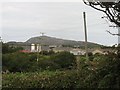
A new estate of bungalows in Porth Dafarch Road
Image: © Eric Jones
Taken: 13 Aug 2009
0.11 miles
2
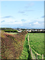
Path between hedge and fence
The path is heading towards Porthdafarch Road in the district of Kingsland, which is on the outskirts of Holyhead.
Image: © Trevor Littlewood
Taken: 9 Oct 2019
0.15 miles
3
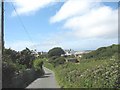
Yr Ogof Farmhouse, Lon yr Ogof
Ogof means "a cave".
Image: © Eric Jones
Taken: 23 Jul 2008
0.18 miles
4
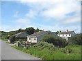
Infilling on Lon yr Ogof
A number of modern bungalows have been built along this section of the lane.
Image: © Eric Jones
Taken: 23 Jul 2008
0.20 miles