
IMAGES TAKEN NEAR TO
Richmond Hill, HOLYHEAD, LL65 2HF
Introduction
This page details the photographs taken nearby to Richmond Hill, LL65 2HF by members of the Geograph project.
The Geograph project started in 2005 with the aim of publishing, organising and preserving representative images for every square kilometre of Great Britain, Ireland and the Isle of Man.

There are currently over 7.5m images from over14,400 individuals and you can help contribute to the project by visiting https://www.geograph.org.uk
Image Map
Images are licensed for reuse under creativecommons.org/licenses/by-sa/2.0
Notes
- Clicking on the map will re-center to the selected point.
- The higher the marker number, the further away the image location is from the centre of the postcode.
Image Listing (149 Images Found)
Images are licensed for reuse under creativecommons.org/licenses/by-sa/2.0
Image
Details
Distance
1
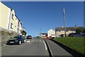
Up Llanfawr Road
Looking along Llanfawr Road in Holyhead. Cycle route 8 uses this road.
Image: © DS Pugh
Taken: 5 Aug 2018
0.02 miles
2
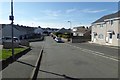
Down Llanfawr Road
Heading towards the docks in Holyhead.
Image: © DS Pugh
Taken: 5 Aug 2018
0.03 miles
4
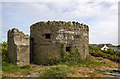
North Wales WWII defences: Holyhead, Anglesey - pillbox (1)
-
Pillbox (variant): DoB ID: S0008121
A circular pillbox known as a Welsh 'mini-castle' stands on a high point near to Skinner's Monument, its loopholes cover the town and Inner Harbour. Built of local stone, it has a low door protected by a blast wall, whilst the roof is of reinforced concrete with stones on top giving it a castellated appearance. This mini-castle is the only one remaining in the Holyhead Harbour area, and has been listed by CADW. This pillbox design has also been used extensively in the Trearddur Bay area.
Image
Image: © Mike Searle
Taken: 13 May 2017
0.08 miles
5
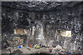
North Wales WWII defences: Holyhead, Anglesey - pillbox (2)
-
Pillbox (variant): DoB ID: S0008121
Interior view.
Image
Image: © Mike Searle
Taken: 13 May 2017
0.08 miles
7
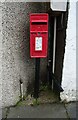
Elizabeth II postbox on London Road, Holyhead
Postbox No. LL65 4.
Image: © JThomas
Taken: 16 Apr 2024
0.10 miles
8
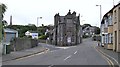
The junction of Llanfawr Road and Turkey Shore
Image: © Eric Jones
Taken: 9 Sep 2010
0.10 miles
9
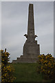
Skinner's Monument
After surviving several life-threatening injuries in the American War of Independence, John MacGregor Skinner became a Captain for the Post Office Service. He came to Wales to command a packet ship and was employed between Holyhead and Dublin, a post he held for 33 years.
He got to know the local people well and was not only respected as a captain, but as a benevolent person who cared for those less fortunate than himself. He turned down the offer of a knighthood, by George IV, so as not to jeopardise his career on the steam packets.
On 30 October 1832 tragedy struck when Captain Skinner and his mate were washed overboard by heavy seas, not half an hour from Holyhead. His death was met with overwhelming grief and money raised by the townsfolk paid for Skinner's Monument to be built to remember his remarkable life.
Information courtesy of BBC.
Image: © Arthur C Harris
Taken: 21 Mar 2013
0.11 miles
10
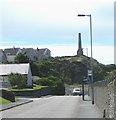
The Skinner Memorial above Turkey Shore Road
Capt John Macgregor Skinner RN, was a one-eyed, one armed, mariner born in America in 1760. (It's interesting that many of Anglesey's great figures - soldiers, sailors, preachers - were one-eyed, one armed or one-legged). After serving with the British navy in the American War of Independence, Skinner became master of a succession of Post Office operated Holyhead to Dublin mail boats. In 1832 he was washed overboard near the North Stack and drowned. A popular man, the townsfolk commemorated him by erecting this obelisk. In the wake of the tragedy a Board of Inquiry recommended the transfer of the packet service from the Post Office to the Admiralty. This is why the pier from which the ferries used to sail became known as the Admiralty Pier.
Image
Image: © Eric Jones
Taken: 4 Jul 2008
0.11 miles