IMAGES TAKEN NEAR TO
Four Mile Bridge, HOLYHEAD, LL65 2DJ
Introduction
This page details the photographs taken nearby to LL65 2DJ by members of the Geograph project.
The Geograph project started in 2005 with the aim of publishing, organising and preserving representative images for every square kilometre of Great Britain, Ireland and the Isle of Man.

There are currently over 7.5m images from over14,400 individuals and you can help contribute to the project by visiting https://www.geograph.org.uk
Image Map
Images are licensed for reuse under creativecommons.org/licenses/by-sa/2.0
Notes
- Clicking on the map will re-center to the selected point.
- The higher the marker number, the further away the image location is from the centre of the postcode.
Image Listing (25 Images Found)
Images are licensed for reuse under creativecommons.org/licenses/by-sa/2.0
Image
Details
Distance
1
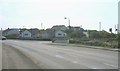
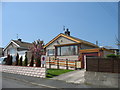
Refail housing estate between Trearddur and Four Mile Bridge
Image: © Eric Jones
Taken: 7 May 2008
0.00 miles
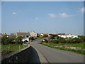
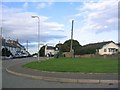
2
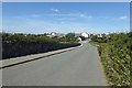
Approaching Trearddur from Rhoscolyn
Image: © David Purchase
Taken: 26 Dec 2016
0.03 miles
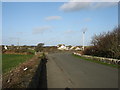
3
Fork in road at bottom of The Avenue
Near Cae'r Sais
Image: © John Firth
Taken: 4 Oct 2011
0.05 miles
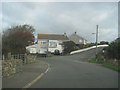
4
Road from Rhoscolyn
Looking towards the B4545 and housing.
Image: © DS Pugh
Taken: 5 Aug 2018
0.06 miles
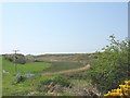
8
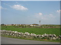
View across farmland towards Plas-rhydbont Farm
Image: © Eric Jones
Taken: 7 May 2008
0.09 miles
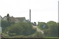
9
Junction
The image taken at SH268780 shows the B4584 running east towards Four Mile Bridge.
Image: © Dave Smethurst
Taken: 19 Aug 2005
0.09 miles