IMAGES TAKEN NEAR TO
Maeshyfryd Bungalows, HOLYHEAD, LL65 2AN
Introduction
This page details the photographs taken nearby to Maeshyfryd Bungalows, LL65 2AN by members of the Geograph project.
The Geograph project started in 2005 with the aim of publishing, organising and preserving representative images for every square kilometre of Great Britain, Ireland and the Isle of Man.

There are currently over 7.5m images from over14,400 individuals and you can help contribute to the project by visiting https://www.geograph.org.uk
Image Map
Images are licensed for reuse under creativecommons.org/licenses/by-sa/2.0
Notes
- Clicking on the map will re-center to the selected point.
- The higher the marker number, the further away the image location is from the centre of the postcode.
Image Listing (137 Images Found)
Images are licensed for reuse under creativecommons.org/licenses/by-sa/2.0
Image
Details
Distance
1
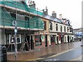
The Sisters, Holyhead
Originally five pubs (The Blossoms, The Globe, The Sydney, The Dublin Packet and The Holland Inn), now 3 pubs (The Blossoms, The Dublin Packet and The Holland Inn) and the Globe chip shop.
Image: © Cod
Taken: Unknown
0.10 miles
2
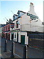
Holland Inn, Holyhead
Located in Rhos Y Gaer Terrace, on the west side
of the A5154 between Station Street and Holborn Road.
Image: © Jaggery
Taken: 26 Mar 2012
0.10 miles
3
The Dublin Packet, Holyhead
Pub in Rhos y gaer Terrace, on the west side of the A5154 between Station Street and Holborn Road.
The Holland Inn http://www.geograph.org.uk/photo/2938488 is on the right.
Image: © Jaggery
Taken: 26 Mar 2012
0.10 miles
4
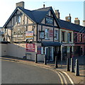
The Blossoms Free House, Holyhead
Pub on the corner of Rhos Y Gaer Terrace and Holborn Road.
Image: © Jaggery
Taken: 26 Mar 2012
0.10 miles
5
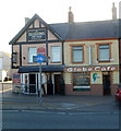
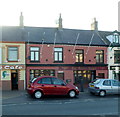
Globe Cafe, Holyhead
Located in Rhos Y Gaer Terrace, next door to The Blossoms pub. http://www.geograph.org.uk/photo/2938501
The Globe was formerly a pub.
Image: © Jaggery
Taken: 26 Mar 2012
0.10 miles
6
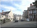
The junctions of Longford, Plas and Maes Hyfryd roads
Image: © Eric Jones
Taken: 21 Jul 2008
0.11 miles
7
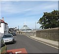
St Mary's Catholic Church from Longford Road
Image: © Eric Jones
Taken: 21 Jul 2008
0.11 miles
8
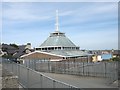
St Mary's Catholic Church - a rear view
This modernistic church was built in 1965. It has seating for 880 worshippers. A primary school, a parish hall, and a library were later added to form a campus between Longford Road and Victoria Road.
Image: © Eric Jones
Taken: 29 May 2008
0.11 miles
9
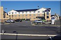
Travelodge, Kingsland Road, Caergybi ,Ynys Gybi/Holyhead, Holy Island
One of the Travelodge chain of hotels. This one is on the corner of Cleveland Avenue and Kingsland Road. It is near the port area, so convenient for anyone travelling late or early, to or from Ireland.
Image: © P L Chadwick
Taken: 28 Sep 2011
0.12 miles
10
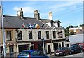
The Dublin Packet and The Holland Inn, Victoria Road, Holyhead
There are three pubs in this block of four buildings, the third not shown in this photograph is 'The Blossom'. The pub with the flags is 'The Dublin Packet'. Originally, the block has five pubs, known locally as "the Sisters". The other two were: 'The Globe' (now a chippy) and 'The Sydney' (now incorporated into the Dublin Packet).
Image: © Eric Jones
Taken: 4 Jul 2008
0.12 miles