IMAGES TAKEN NEAR TO
New Park Close, HOLYHEAD, LL65 1NA
Introduction
This page details the photographs taken nearby to New Park Close, LL65 1NA by members of the Geograph project.
The Geograph project started in 2005 with the aim of publishing, organising and preserving representative images for every square kilometre of Great Britain, Ireland and the Isle of Man.

There are currently over 7.5m images from over14,400 individuals and you can help contribute to the project by visiting https://www.geograph.org.uk
Image Map
Images are licensed for reuse under creativecommons.org/licenses/by-sa/2.0
Notes
- Clicking on the map will re-center to the selected point.
- The higher the marker number, the further away the image location is from the centre of the postcode.
Image Listing (100 Images Found)
Images are licensed for reuse under creativecommons.org/licenses/by-sa/2.0
Image
Details
Distance
1
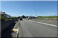
New Park Road
Passing a public park on the right.
Image: © DS Pugh
Taken: 5 Aug 2018
0.03 miles
3
Llyfrgell - Library, Newry Street, Holyhead
Image: © Eric Jones
Taken: 24 Jul 2009
0.07 miles
4
Basketball Court at the Porth-y-Felin Road Park
Image: © Eric Jones
Taken: 21 Jul 2008
0.07 miles
5

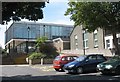
The main block of Ysgol Uwchradd Caergybi
Image: © Eric Jones
Taken: 24 Jul 2009
0.08 miles
6

Ysgol Uwchradd Caergybi High School - Britain's oldest comp.
The school was formed in 1949 with the amalgamation of Holyhead Grammar and St Cybi Secondary school. Ysgol Thomas Jones, Amlwch claims the title of the first purpose built comprehensive. Ysgol Gyfun Llangefni is claimed by some to be Britain's first comprehensive.
Image: © Eric Jones
Taken: 28 Jun 2008
0.08 miles
7
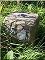
Holyhead Fundamental Benchmark
Easy bag with Alex Cameron before our RIB trip to the Skerries.
Image: © Rude Health
Taken: 13 Sep 2015
0.09 miles
10
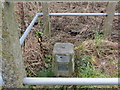
Ordnance Survey Fundamental Bench Mark - Holyhead
This can be found in parkland off Port-Y-Felin Road in Holyhead. The benchmark height is recorded as being 36.1 metres above sea level. For more detail see http://www.bench-marks.org.uk/bm1086
Image: © Peter Wood
Taken: 5 Dec 2017
0.09 miles