IMAGES TAKEN NEAR TO
Station Road, RHOSNEIGR, LL64 5QY
Introduction
This page details the photographs taken nearby to Station Road, LL64 5QY by members of the Geograph project.
The Geograph project started in 2005 with the aim of publishing, organising and preserving representative images for every square kilometre of Great Britain, Ireland and the Isle of Man.

There are currently over 7.5m images from over14,400 individuals and you can help contribute to the project by visiting https://www.geograph.org.uk
Image Map (Loading...)


Getting Data...Please wait
Leaflet Map data © OpenStreetMap
Images are licensed for reuse under creativecommons.org/licenses/by-sa/2.0
Notes
- Clicking on the map will re-center to the selected point.
- The higher the marker number, the further away the image location is from the centre of the postcode.
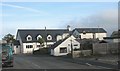
Image Listing (50 Images Found)
Images are licensed for reuse under creativecommons.org/licenses/by-sa/2.0
Image
Details
Distance
1
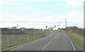
View west along the A4080 towards Glan Morfa and the Anglesey Golf Club Clubhouse
Image: © Eric Jones
Taken: 14 Nov 2008
0.03 miles
2
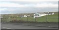
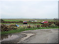
The eastern section of the Shoreside Caravan Park at Ty Mawr
The photo shows a camp shop, Ty Mawr farmhouse and to the left of the shop, in the middle distance, the clubhouse of the Anglesey Golf Club. The first link shows an aerial view of this part of Rhosneigr.
http://www.shoresidecamping.co.uk/Gallery/AerialPics.html
http://www.shoresidecamping.co.uk/
Image: © Eric Jones
Taken: 14 Nov 2008
0.04 miles
3
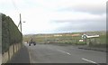
Approaching the north-western bend of the A 4080 loop
The A 4080 loops round Llyn Maelor lake.
Image: © Eric Jones
Taken: 14 Nov 2008
0.07 miles
4
Glan Morfa cottage on the A 4080
Glan Morfa means "side of the sea-marsh".
Image: © Eric Jones
Taken: 14 Nov 2008
0.07 miles
5
Waste land by sharp bend in A4080
Taken from layby The Afon Crigyll can be seen with the footbridge
Image: © John Firth
Taken: 3 Oct 2011
0.07 miles
6
The Anglesey Golf Course Club House, Station Road, Rhosneigr
This is the club house of the oldest golf club in Anglesey.
http://www.angleseygolfclub.co.uk/
Image: © Eric Jones
Taken: 14 Nov 2008
0.07 miles

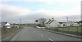
8
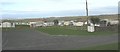
The western section of the Shoreside Caravan Park
The park is divided into two halves by the A 4080.
http://www.shoresidecamping.co.uk/
Image
Image: © Eric Jones
Taken: 14 Nov 2008
0.11 miles
9
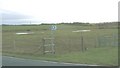
Footpath and waterlogged farmland south of the A 4080
Image: © Eric Jones
Taken: 14 Nov 2008
0.13 miles
10
The former Eglwys Crist/Christ Church now converted into holiday units
This church was built in 1908 as a chapel of ease, Llanfaelog Church being distant from the village. It was closed in 1995, and left to go into rack and ruin. Lately, the building has been beautifully refurbished and converted into two holiday let units - known as Dave's Pads.
http://www.davespads.co.uk/rhosneigr.html
Image: © Eric Jones
Taken: 14 Nov 2008
0.14 miles