IMAGES TAKEN NEAR TO
Crigyll Road, RHOSNEIGR, LL64 5QS
Introduction
This page details the photographs taken nearby to Crigyll Road, LL64 5QS by members of the Geograph project.
The Geograph project started in 2005 with the aim of publishing, organising and preserving representative images for every square kilometre of Great Britain, Ireland and the Isle of Man.

There are currently over 7.5m images from over14,400 individuals and you can help contribute to the project by visiting https://www.geograph.org.uk
Image Map (Loading...)


Getting Data...Please wait
Leaflet Map data © OpenStreetMap
Images are licensed for reuse under creativecommons.org/licenses/by-sa/2.0
Notes
- Clicking on the map will re-center to the selected point.
- The higher the marker number, the further away the image location is from the centre of the postcode.
Image Listing (62 Images Found)
Images are licensed for reuse under creativecommons.org/licenses/by-sa/2.0
Image
Details
Distance
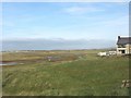
2
The Anglesey Coastal Path at Rhosneigr
The Anglesey Coastal Path heading north at Rhosneigr.
Image: © Jeff Buck
Taken: 17 May 2016
0.05 miles
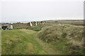
3
The A4080 (Station Road) at Rhosneigr
The A4080 heading north-east out of Rhosneigr.
Image: © Jeff Buck
Taken: 17 May 2016
0.06 miles
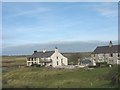
5
Christ Church Holiday Home, Rhosneigr
Built in 1908, formerly a church.
Image: © Chris Andrews
Taken: 19 Apr 2015
0.08 miles
6
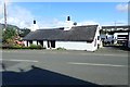
Pen Morfa, Rhosneigr
Old cottage on Station Road
Image: © Eirian Evans
Taken: 12 Aug 2019
0.08 miles
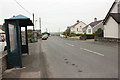
7
The former Eglwys Crist/Christ Church now converted into holiday units
This church was built in 1908 as a chapel of ease, Llanfaelog Church being distant from the village. It was closed in 1995, and left to go into rack and ruin. Lately, the building has been beautifully refurbished and converted into two holiday let units - known as Dave's Pads.
http://www.davespads.co.uk/rhosneigr.html
Image: © Eric Jones
Taken: 14 Nov 2008
0.09 miles

9
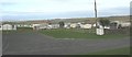
The western section of the Shoreside Caravan Park
The park is divided into two halves by the A 4080.
http://www.shoresidecamping.co.uk/
Image
Image: © Eric Jones
Taken: 14 Nov 2008
0.11 miles