IMAGES TAKEN NEAR TO
RHOSNEIGR, LL64 5JR
Introduction
This page details the photographs taken nearby to LL64 5JR by members of the Geograph project.
The Geograph project started in 2005 with the aim of publishing, organising and preserving representative images for every square kilometre of Great Britain, Ireland and the Isle of Man.

There are currently over 7.5m images from over14,400 individuals and you can help contribute to the project by visiting https://www.geograph.org.uk
Image Map (Loading...)


Getting Data...Please wait
Leaflet Map data © OpenStreetMap
Images are licensed for reuse under creativecommons.org/licenses/by-sa/2.0
Notes
- Clicking on the map will re-center to the selected point.
- The higher the marker number, the further away the image location is from the centre of the postcode.
Image Listing (13 Images Found)
Images are licensed for reuse under creativecommons.org/licenses/by-sa/2.0
Image
Details
Distance
1
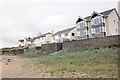
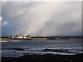
Beach community at Traeth Llydan
A group of villas near the rocks of Cerrig y Defaid near Traeth Llydan.
Image: © Jeff Buck
Taken: 17 May 2016
0.02 miles
2
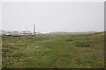
The Anglesey Coastal Path at Tywyn Llyn
Heading north on the Anglesey Coastal Path as the sea mist closes in.
Image: © Jeff Buck
Taken: 17 May 2016
0.05 miles
3

Sea view
Looking over the gardens of holiday residences by Cerrig y Defaid to Traeth Llydan.
Image: © Jonathan Wilkins
Taken: 31 Aug 2013
0.05 miles
4
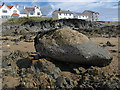
Glacial erratic boulder
In such an exposed location, only the heaviest and least mobile boulders will remain where they were dropped by melting ice-sheets at the end of the last ice-age. The camera bag gives a scale. The rock on which the boulder is resting is described as "hornfels arising from intrusion of the Coedana granite into probably sedimentary rocks of Ediacaran age, 542 to 635 million years".
Image: © Jonathan Wilkins
Taken: 31 Aug 2013
0.06 miles
5
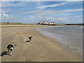
Traeth Llydan
The beach and dunes at Traeth Llydan. Rhosneigr can be seen in the distance.
Image: © Jeff Buck
Taken: 17 May 2016
0.07 miles
7
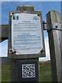
Slate QR code
Not being a smartphone user, I had no idea what this QR code said, but it is fascinating to see it applied as an engraving on slate. The idea of the modern technology applied to a bit of 500 million year-old Cambrian sea floor is most stimulating. The plain text explains the use of ponies to graze down scrub and the need to control dogs within the pasture.
The QR code turns out only to convey the website of nearby holiday lets, which I thought was a disappointment.
Image: © Jonathan Wilkins
Taken: 31 Aug 2013
0.08 miles
8
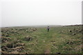
The Anglesey Coastal Path at Tywyn Llyn
Heading north on the Anglesey Coastal Path as the sea mist closes in.
Image: © Jeff Buck
Taken: 17 May 2016
0.10 miles
9
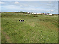
Caravan site
Looking over coastal pasture and dunes to a small private caravan site near to Traeth Llydan.
Image: © Jonathan Wilkins
Taken: 31 Aug 2013
0.14 miles
10
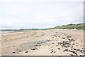
Traeth Llydan and Cerrig y Defaid
Fine, smooth sand curves round to the rocks known as Cerrig y Defaid. It is not obvious how sheep (defaid) are associated with the rocks. Beach-side villas and a sublime sky complete the scene
Image: © Jonathan Wilkins
Taken: 31 Aug 2013
0.15 miles