IMAGES TAKEN NEAR TO
Llanfaelog, TY CROES, LL63 5UB
Introduction
This page details the photographs taken nearby to LL63 5UB by members of the Geograph project.
The Geograph project started in 2005 with the aim of publishing, organising and preserving representative images for every square kilometre of Great Britain, Ireland and the Isle of Man.

There are currently over 7.5m images from over14,400 individuals and you can help contribute to the project by visiting https://www.geograph.org.uk
Image Map (Loading...)


Getting Data...Please wait
Leaflet Map data © OpenStreetMap
Images are licensed for reuse under creativecommons.org/licenses/by-sa/2.0
Notes
- Clicking on the map will re-center to the selected point.
- The higher the marker number, the further away the image location is from the centre of the postcode.
Image Listing (10 Images Found)
Images are licensed for reuse under creativecommons.org/licenses/by-sa/2.0
Image
Details
Distance
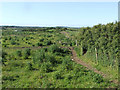
2
Climbing Yr Allt
A "gallt" (here mutated to "allt" by the "yr" (=the)) means a wooded hillside. The footpath to the right leads past Plas Llanfaelog to the A 4080.
Image: © Eric Jones
Taken: 14 Nov 2008
0.04 miles
3
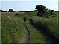
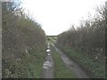
Road unsuitable for wide vehicles
This lane leading to Pentre Traeth has long grass growing in the centre of the road, as well as having tall plants growing at the sides, making it very narrow to drive down
Image: © Nigel Williams
Taken: 14 Jun 2006
0.09 miles
4
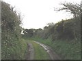
Potholed minor road between high hedges
This is the section of the road between Pentre-traeth and Yr Allt.
Image: © Eric Jones
Taken: 14 Nov 2008
0.11 miles
5
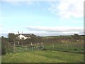
View north-eastwards along the line of the footpath from Plas Llanfaelog to Yr Allt
The white gable of Yr Allt cottage can be seen on the skyline.
Image: © Eric Jones
Taken: 14 Nov 2008
0.13 miles
6
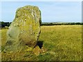
Standing Stone
A Standing Stone at the side of the lake at Plas Farm. There is what looks like a barrow nearby. I've searched for information about this site without success - perhaps someone can help.
Image: © Brian Webster
Taken: 25 Jul 2018
0.15 miles
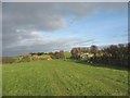
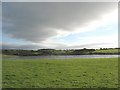
7
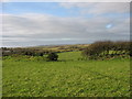
View across rough grazing towards a rocky knoll
Image: © Eric Jones
Taken: 14 Nov 2008
0.17 miles
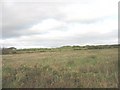
8
Rough grazing
looking North into a field of rough grazing near to Rhosneigr
Image: © Nigel Williams
Taken: 14 Jun 2006
0.17 miles
9
A man made lake at Plas Llanfaelog Farm
This lake is of recent origin and is not shown either on OS maps or on Magic. A natural hollow has been utilised to create the lake.
Image: © Eric Jones
Taken: 23 Aug 2008
0.19 miles