IMAGES TAKEN NEAR TO
Llangristiolus, BODORGAN, LL62 5PP
Introduction
This page details the photographs taken nearby to LL62 5PP by members of the Geograph project.
The Geograph project started in 2005 with the aim of publishing, organising and preserving representative images for every square kilometre of Great Britain, Ireland and the Isle of Man.

There are currently over 7.5m images from over14,400 individuals and you can help contribute to the project by visiting https://www.geograph.org.uk
Image Map
Images are licensed for reuse under creativecommons.org/licenses/by-sa/2.0
Notes
- Clicking on the map will re-center to the selected point.
- The higher the marker number, the further away the image location is from the centre of the postcode.
Image Listing (12 Images Found)
Images are licensed for reuse under creativecommons.org/licenses/by-sa/2.0
Image
Details
Distance
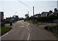
2
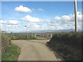
Road junction in the village of Llangristiolus
Image: © Eric Jones
Taken: 2 May 2008
0.03 miles
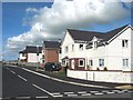
5
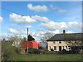
Llangristiolus village
Tucked away from main roads some 2 miles SW of Llangefni.
Image: © Gordon Hatton
Taken: 29 Sep 2023
0.08 miles
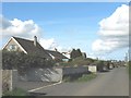
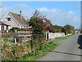
6
Bungalows at Llangristiolus
A ribbon of modern bungalow development along the narrow lane leading out of Llangristiolus.
Image: © Christopher Hall
Taken: 9 Apr 2015
0.10 miles
7
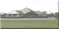
Ysgol Henblas Primary School, Llangristiolus
Image: © Eric Jones
Taken: 2 May 2008
0.17 miles

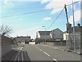
10
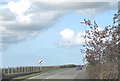
The B4422 on the northern edge of the village of Llangristiolus
Image: © Eric Jones
Taken: 2 May 2008
0.23 miles