IMAGES TAKEN NEAR TO
Llangadwaladr, BODORGAN, LL62 5LY
Introduction
This page details the photographs taken nearby to LL62 5LY by members of the Geograph project.
The Geograph project started in 2005 with the aim of publishing, organising and preserving representative images for every square kilometre of Great Britain, Ireland and the Isle of Man.

There are currently over 7.5m images from over14,400 individuals and you can help contribute to the project by visiting https://www.geograph.org.uk
Image Map
Images are licensed for reuse under creativecommons.org/licenses/by-sa/2.0
Notes
- Clicking on the map will re-center to the selected point.
- The higher the marker number, the further away the image location is from the centre of the postcode.
Image Listing (6 Images Found)
Images are licensed for reuse under creativecommons.org/licenses/by-sa/2.0
Image
Details
Distance
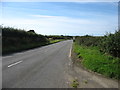
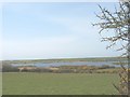
2
View north from the A 4080 towards Llyn Coron
Image: © Eric Jones
Taken: 30 Oct 2008
0.12 miles
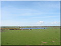
4
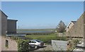
Llyn Coron lake seen from the village of Llangadwaladr
Image: © Eric Jones
Taken: 23 Apr 2008
0.18 miles
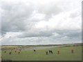
5
An inlet of Llyn Coron
Llyn Coron is a comparatively shallow lake, but is popular with fishermen.
http://www3.interscience.wiley.com/journal/23686/abstract?CRETRY=1&SRETRY=0
Image: © Eric Jones
Taken: 23 Apr 2008
0.24 miles