IMAGES TAKEN NEAR TO
BODORGAN, LL62 5LT
Introduction
This page details the photographs taken nearby to LL62 5LT by members of the Geograph project.
The Geograph project started in 2005 with the aim of publishing, organising and preserving representative images for every square kilometre of Great Britain, Ireland and the Isle of Man.

There are currently over 7.5m images from over14,400 individuals and you can help contribute to the project by visiting https://www.geograph.org.uk
Image Map
Images are licensed for reuse under creativecommons.org/licenses/by-sa/2.0
Notes
- Clicking on the map will re-center to the selected point.
- The higher the marker number, the further away the image location is from the centre of the postcode.
Image Listing (4 Images Found)
Images are licensed for reuse under creativecommons.org/licenses/by-sa/2.0
Image
Details
Distance
1
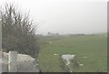
Trefri farmhouse emerges from the sea mist
Image: © Eric Jones
Taken: 23 Apr 2008
0.02 miles
2
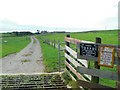
Warning to Geographers
The farm in the background is in SH3666.
Image: © James Allan
Taken: 5 Sep 2007
0.21 miles
3
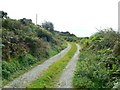
Road to Tyn Llwydan
Private road leading south from Trefri farm road end.
Image: © James Allan
Taken: 5 Sep 2007
0.21 miles
4
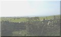
Cattle grazing on Cwningar Trefri warren
In the distance beyond the farmhouse can be seen the Dinas Bach headland.
Image: © Eric Jones
Taken: 23 Apr 2008
0.22 miles