IMAGES TAKEN NEAR TO
Trefdraeth, BODORGAN, LL62 5HF
Introduction
This page details the photographs taken nearby to LL62 5HF by members of the Geograph project.
The Geograph project started in 2005 with the aim of publishing, organising and preserving representative images for every square kilometre of Great Britain, Ireland and the Isle of Man.

There are currently over 7.5m images from over14,400 individuals and you can help contribute to the project by visiting https://www.geograph.org.uk
Image Map
Images are licensed for reuse under creativecommons.org/licenses/by-sa/2.0
Notes
- Clicking on the map will re-center to the selected point.
- The higher the marker number, the further away the image location is from the centre of the postcode.
Image Listing (12 Images Found)
Images are licensed for reuse under creativecommons.org/licenses/by-sa/2.0
Image
Details
Distance
1
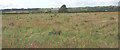
Glanrafon Farm
Coal was mined on Glanrafon Farm up to the 1850s by a Caernarfon-based company. The pit was known as Pwll Marquis as the land belonged to Paget, the Marquis of Anglesey.
Image: © Eric Jones
Taken: 13 Jun 2008
0.00 miles
4
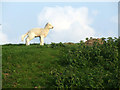
Lamb on the embankment
A lamb on top of the embankment that keeps the River Cefni from flooding the surrounding land
Image: © Nigel Williams
Taken: 13 May 2006
0.13 miles
5
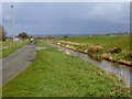
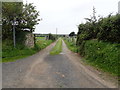
Alongside the Afon Cefni
From left to right - a long straight road, the North Side Drain,and a high embankment bounding the main channel of Afon Cefni. The north side drain receives all water from the adjacent fields downstream from Llangefni.
Image: © Oliver Dixon
Taken: 7 Apr 2016
0.14 miles
6
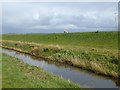
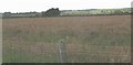
North Side Drain, Afon Cefni
The north side drain receives all water from the adjacent fields downstream from Llangefni. Beyond is the high embankment - well above the level of the surrounding land - bounding the main channel of the Afon Cefni.
Image: © Oliver Dixon
Taken: 7 Apr 2016
0.15 miles
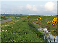
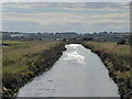
7

The north drainage channel from the Paradwys-Malltraeth road
Image: © Eric Jones
Taken: 13 Jun 2008
0.18 miles
8
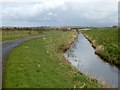
North Side Drain, Afon Cefni
The north side drain receives all water from the adjacent fields downstream from Llangefni. A straight level road runs alongside. To the right is the embankment bounding the main channel of the river.
Image: © Oliver Dixon
Taken: 7 Apr 2016
0.18 miles
9
Road and drainage ditch alongside the Cefni river
This road and drainage ditch run alongside the Cefni river, which is the other side of the built up embankment
Image: © Nigel Williams
Taken: 13 May 2006
0.19 miles
10
Afon Cefni
Looking west along the Afon Cefni from Pont Marquis.
Image: © Alan White
Taken: 5 Jul 2014
0.21 miles