IMAGES TAKEN NEAR TO
Cerrigceinwen, BODORGAN, LL62 5EE
Introduction
This page details the photographs taken nearby to LL62 5EE by members of the Geograph project.
The Geograph project started in 2005 with the aim of publishing, organising and preserving representative images for every square kilometre of Great Britain, Ireland and the Isle of Man.

There are currently over 7.5m images from over14,400 individuals and you can help contribute to the project by visiting https://www.geograph.org.uk
Image Map
Images are licensed for reuse under creativecommons.org/licenses/by-sa/2.0
Notes
- Clicking on the map will re-center to the selected point.
- The higher the marker number, the further away the image location is from the centre of the postcode.
Image Listing (3 Images Found)
Images are licensed for reuse under creativecommons.org/licenses/by-sa/2.0
Image
Details
Distance
1
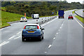
Layby on the North Wales Expressway near to Cerrigceinwen
Image: © David Dixon
Taken: 24 Sep 2017
0.13 miles
2
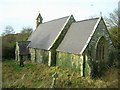
Eglwys St. Ceinwen, Cerrigceinwen.
A view of St. Ceinwen's Church, Cerrigceinwen.
Image: © Stephen Elwyn RODDICK
Taken: 17 Jan 2006
0.23 miles
3
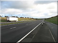
The A55 looking towards Bangor
Seen from a lay-by on the westbound carriageway.
Image: © David Purchase
Taken: 14 Dec 2019
0.24 miles