IMAGES TAKEN NEAR TO
BODORGAN, LL62 5BW
Introduction
This page details the photographs taken nearby to LL62 5BW by members of the Geograph project.
The Geograph project started in 2005 with the aim of publishing, organising and preserving representative images for every square kilometre of Great Britain, Ireland and the Isle of Man.

There are currently over 7.5m images from over14,400 individuals and you can help contribute to the project by visiting https://www.geograph.org.uk
Image Map
Images are licensed for reuse under creativecommons.org/licenses/by-sa/2.0
Notes
- Clicking on the map will re-center to the selected point.
- The higher the marker number, the further away the image location is from the centre of the postcode.
Image Listing (9 Images Found)
Images are licensed for reuse under creativecommons.org/licenses/by-sa/2.0
Image
Details
Distance

5
Junction with the road leading to the village of Bethel
Image: © Eric Jones
Taken: 23 Apr 2008
0.20 miles
6
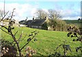
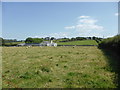
Cae'r Ddol, Bodorgan, Anglesey.
A view of a small traditional cottage called Cae'r Ddol. Not much has changed in this view in the past one hundred years.
Image: © Stephen Elwyn RODDICK
Taken: 14 Jan 2006
0.20 miles
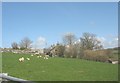
7
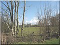
A diversion of water from Afon Gwna to Llyn Coron
This is a flood prevention scheme
Image: © Eric Jones
Taken: 23 Apr 2008
0.22 miles
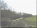
8
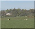
One of a pair of small holdings on a hill above Afon Gwna
Image: © Eric Jones
Taken: 23 Apr 2008
0.23 miles
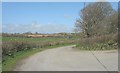
9
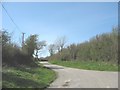
Minor road leading past Tre-Ddafydd-uchaf
Image: © Eric Jones
Taken: 23 Apr 2008
0.24 miles