IMAGES TAKEN NEAR TO
Malltraeth, BODORGAN, LL62 5AU
Introduction
This page details the photographs taken nearby to LL62 5AU by members of the Geograph project.
The Geograph project started in 2005 with the aim of publishing, organising and preserving representative images for every square kilometre of Great Britain, Ireland and the Isle of Man.

There are currently over 7.5m images from over14,400 individuals and you can help contribute to the project by visiting https://www.geograph.org.uk
Image Map
Images are licensed for reuse under creativecommons.org/licenses/by-sa/2.0
Notes
- Clicking on the map will re-center to the selected point.
- The higher the marker number, the further away the image location is from the centre of the postcode.
Image Listing (78 Images Found)
Images are licensed for reuse under creativecommons.org/licenses/by-sa/2.0
Image
Details
Distance
1
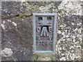
Ordnance Survey Flush Bracket S7594
This bracket can be found on a former chapel building in Maltraeth. The benchmark height is recorded as being 4.932 metres above sea level. For more detail see : http://www.bench-marks.org.uk/bm16408
Image: © Peter Wood
Taken: 6 Dec 2017
0.01 miles
2
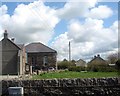
Capel a thy capel Sardis Chapel and chapel house, Malltraeth
Sardis is a Calvinistic Methodist chapel.
Image: © Eric Jones
Taken: 2 May 2008
0.01 miles
3

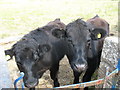
Bullocks near Malltraeth Bridge
The railed-off area in the background is the top of a tidal flap.
Image: © Eric Jones
Taken: 13 Jun 2008
0.02 miles
4
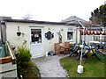
Riverside Cafe, Malltraeth
A simple, homely cafe just east of the village centre, very popular with cyclists.
Image: © Oliver Dixon
Taken: 7 Apr 2016
0.02 miles
6
Bullocks at the gate next to the bus stop in the centre of Malltraeth
Image: © Eric Jones
Taken: 13 Jun 2008
0.02 miles

8
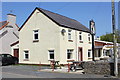
The Joiners Arms, Malltraeth
The Joiners Arms in Malltraeth is the last of two pubs remaining in the village. The other pub, the Royal Oak, closed in 2015.
Image: © Jeff Buck
Taken: 3 May 2017
0.03 miles
9
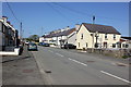
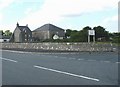
High Street (A4080) at Malltraeth
Looking north along High Street (the A4080) at Malltraeth on Anglesey.
Image: © Jeff Buck
Taken: 3 May 2017
0.04 miles
10

Houses between the road and rail bridges over the Cefni at Malltraeth
Image: © Eric Jones
Taken: 2 May 2008
0.04 miles