IMAGES TAKEN NEAR TO
Malltraeth, BODORGAN, LL62 5AT
Introduction
This page details the photographs taken nearby to LL62 5AT by members of the Geograph project.
The Geograph project started in 2005 with the aim of publishing, organising and preserving representative images for every square kilometre of Great Britain, Ireland and the Isle of Man.

There are currently over 7.5m images from over14,400 individuals and you can help contribute to the project by visiting https://www.geograph.org.uk
Image Map
Images are licensed for reuse under creativecommons.org/licenses/by-sa/2.0
Notes
- Clicking on the map will re-center to the selected point.
- The higher the marker number, the further away the image location is from the centre of the postcode.
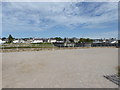
Image Listing (83 Images Found)
Images are licensed for reuse under creativecommons.org/licenses/by-sa/2.0
Image
Details
Distance
1
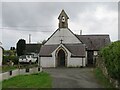
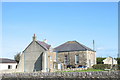
Church of Christ the King, Malltraeth
Small church tucked away behind the main village street.
Image: © Gordon Hatton
Taken: 24 Sep 2023
0.01 miles
2
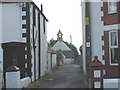
Christ the King at the back of Malltraeth High Street
This church, built in 1873, was initially St Elizabeth's Mission Hall and schoolroom. In 1959 it acquired the status of a church and was renamed Christ the King.
Image: © Eric Jones
Taken: 13 Jun 2008
0.01 miles
3
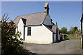
Eglwys Crist y Brenin, Malltraeth
Eglwys Crist y Brenin (Christ the King Church) is a small church tucked away along a small lane in the village of Malltraeth.
Image: © Jeff Buck
Taken: 3 May 2017
0.01 miles
4
North Wales WWII defences: Malltraeth, Anglesey - Anti-Tank Blocks (1)
-
Anti-Tank Block: DoB ID: S0015614
Four badly eroded anti-tank blocks block the entrance to the small slipway adjacent to the bridge over the mouth of the Afon Cefni at Malltraeth. All have recesses to accommodate a removable barrier such as a telegraph pole.
Image
Image: © Mike Searle
Taken: 13 May 2017
0.02 miles
5
North Wales WWII defences: Malltraeth, Anglesey - Anti-Tank Blocks (2)
-
Anti-Tank Block: DoB ID: S0015614
Image: © Mike Searle
Taken: 13 May 2017
0.02 miles
6
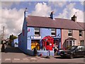
Malltraeth, Post Office.
One of the colourful buildings that have helped Malltraeth gain the local nick name of "Ballamory".
Image: © Stephen Elwyn RODDICK
Taken: 3 Apr 2006
0.03 miles
7
Sardis Calvinistic Methodist Chapel
Sardis was built in 1860 and enlarged in the 1890s.
Image: © Eric Jones
Taken: 7 Oct 2006
0.03 miles
8
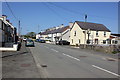
High Street (A4080) at Malltraeth
Looking north along High Street (the A4080) at Malltraeth on Anglesey.
Image: © Jeff Buck
Taken: 3 May 2017
0.04 miles
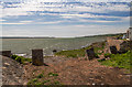
9
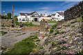
Malltraeth from the other side of the Cefni river
Taken from the Anglesey Coast Path
Image: © Eirian Evans
Taken: 10 Jul 2015
0.04 miles
10

Clwt Glas, Malltraeth
'Clwt Glas' (Green Patch) was an area of land at the lower end of Malltraeth and was essentially the reverse side of a mound built as part of the scheme to reclaim the Cefni Marsh (Cors Ddyga) during the latter years of the 18th Century. It was transformed as a community project with the help of several grants into a picnic area, garden and information point, and opened by Colin Jackson in September 2010.
Image: © Eirian Evans
Taken: 10 Jul 2015
0.04 miles