IMAGES TAKEN NEAR TO
High Street, BODORGAN, LL62 5AS
Introduction
This page details the photographs taken nearby to High Street, LL62 5AS by members of the Geograph project.
The Geograph project started in 2005 with the aim of publishing, organising and preserving representative images for every square kilometre of Great Britain, Ireland and the Isle of Man.

There are currently over 7.5m images from over14,400 individuals and you can help contribute to the project by visiting https://www.geograph.org.uk
Image Map
Images are licensed for reuse under creativecommons.org/licenses/by-sa/2.0
Notes
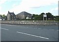
- Clicking on the map will re-center to the selected point.
- The higher the marker number, the further away the image location is from the centre of the postcode.
Image Listing (83 Images Found)
Images are licensed for reuse under creativecommons.org/licenses/by-sa/2.0
Image
Details
Distance
1
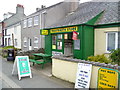
The Malltraeth Store
Convenience store and chippy.
Image: © Jeremy Bolwell
Taken: 4 May 2015
0.00 miles
2
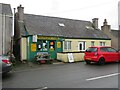
Village shop, Malltraeth
Fish and chips, pizzas, hot baps. What more could one wish for?
Image: © Gordon Hatton
Taken: 24 Sep 2023
0.01 miles
3
The High Street, Malltraeth
Malltraeth began life as a camp for workers engaged in draining the marshland and maps up to the 1960s name the village as "Malltraeth Yard".
Image: © Eric Jones
Taken: 13 Jun 2008
0.01 miles
4

Village shop Malltraeth
Includes Fish and Chips!
Image: © John Firth
Taken: 8 Oct 2010
0.01 miles
5
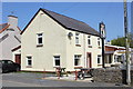
The Joiners Arms, Malltraeth
The Joiners Arms in Malltraeth is the last of two pubs remaining in the village. The other pub, the Royal Oak, closed in 2015.
Image: © Jeff Buck
Taken: 3 May 2017
0.03 miles
6
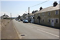
High Street (A4080), Malltraeth
Looking south along High Street (the A4080) at Malltraeth on Anglesey. The pub on the right is The Royal Oak which closed in 2015.
Image: © Jeff Buck
Taken: 3 May 2017
0.03 miles
7
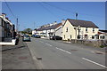
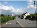
High Street (A4080) at Malltraeth
Looking north along High Street (the A4080) at Malltraeth on Anglesey.
Image: © Jeff Buck
Taken: 3 May 2017
0.03 miles
8
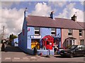
Malltraeth, Post Office.
One of the colourful buildings that have helped Malltraeth gain the local nick name of "Ballamory".
Image: © Stephen Elwyn RODDICK
Taken: 3 Apr 2006
0.04 miles
9
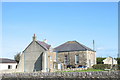
Sardis Calvinistic Methodist Chapel
Sardis was built in 1860 and enlarged in the 1890s.
Image: © Eric Jones
Taken: 7 Oct 2006
0.04 miles