IMAGES TAKEN NEAR TO
Malltraeth, BODORGAN, LL62 5AP
Introduction
This page details the photographs taken nearby to LL62 5AP by members of the Geograph project.
The Geograph project started in 2005 with the aim of publishing, organising and preserving representative images for every square kilometre of Great Britain, Ireland and the Isle of Man.

There are currently over 7.5m images from over14,400 individuals and you can help contribute to the project by visiting https://www.geograph.org.uk
Image Map
Images are licensed for reuse under creativecommons.org/licenses/by-sa/2.0
Notes
- Clicking on the map will re-center to the selected point.
- The higher the marker number, the further away the image location is from the centre of the postcode.
Image Listing (9 Images Found)
Images are licensed for reuse under creativecommons.org/licenses/by-sa/2.0
Image
Details
Distance
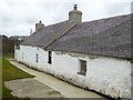
2
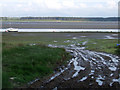
Muddy track on the estuary
This muddy track leads from the tarmac road on to the banks of the estuary of the river Cefni near to Malltraeth
Image: © Nigel Williams
Taken: 13 May 2006
0.14 miles
3
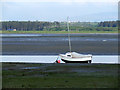
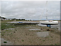
The River Cefni at low tide
A small boat alongside the River Cefni at low tide, which exposes the Malltraeth sands
Image: © Nigel Williams
Taken: 13 May 2006
0.14 miles
4
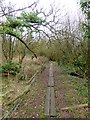
Anglesey Coast Path at Malltraeth
This section of the Anglesey Coast Path (and by extension, the Wales Coast Path) links two road sections. Being level and very damp, boards have been laid to assist walkers.
Image: © Oliver Dixon
Taken: 7 Apr 2016
0.17 miles
5
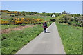
The Anglesey Coastal Path near Malltraeth
The Anglesey Coastal Path heading west along an unnamed lane to the west of Malltraeth.
Image: © Jeff Buck
Taken: 3 May 2017
0.17 miles
6
Boat aground
A boat at a dried out mooring on the edge of the Afon Cefni channel.
Image: © Jonathan Wilkins
Taken: 30 Jun 2012
0.18 miles
7
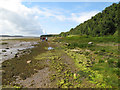
Tideline walkers
A party of geologists walking along the Malltraeth shore on an organised excursion.
Image: © Jonathan Wilkins
Taken: 30 Jun 2012
0.18 miles
8
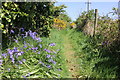
Bluebells on the Anglesey Coastal Path
The Anglesey Coastal Path heading east into the coastal village of Malltraeth.
Image: © Jeff Buck
Taken: 3 May 2017
0.21 miles
9
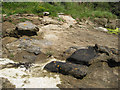
Concretions in sandstone
Variable cementing of the sandstone, Carboniferous in age, by carbonates has resulted in irregular weathering and the appearance of large, dark-coloured nodules on the eroded surfaces. The presence of bedding planes passing straight through some nodules is indicative of the structure being secondary in nature. The dark colour is largely due to the slow ablation of the surface compared to less heavily-cemented areas, and the surface is stable enough to be colonised by lichens (yellow Caloplaca is prominent).
Image: © Jonathan Wilkins
Taken: 30 Jun 2012
0.22 miles