IMAGES TAKEN NEAR TO
Brynsiencyn, LLANFAIRPWLLGWYNGYLL, LL61 6TJ
Introduction
This page details the photographs taken nearby to LL61 6TJ by members of the Geograph project.
The Geograph project started in 2005 with the aim of publishing, organising and preserving representative images for every square kilometre of Great Britain, Ireland and the Isle of Man.

There are currently over 7.5m images from over14,400 individuals and you can help contribute to the project by visiting https://www.geograph.org.uk
Image Map
Images are licensed for reuse under creativecommons.org/licenses/by-sa/2.0
Notes
- Clicking on the map will re-center to the selected point.
- The higher the marker number, the further away the image location is from the centre of the postcode.
Image Listing (10 Images Found)
Images are licensed for reuse under creativecommons.org/licenses/by-sa/2.0
Image
Details
Distance
1

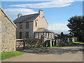
Yr Ogof, a delightful country cottage near the old Cyttir limestone quarries
Yr Ogof means "the cave".
Image: © Eric Jones
Taken: 13 Jun 2008
0.02 miles

3

Beef herd at Cefn Dderwen Farm
Cefn Dderwen means "oakridge" The town in the background, across the Menai Straits, is Caernarfon. Up to the 1950s, Caernarfon was the shopping and entertainment centre for the inhabitants of South West Anglesey with a number of ferries crossing the Straits.
Image: © Eric Jones
Taken: 13 Jun 2004
0.14 miles
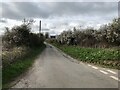
4
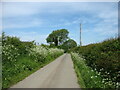
A country lane leading to Brynsiencyn
Image: © David Purchase
Taken: 2 Jun 2021
0.16 miles
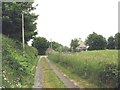
5
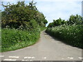
Southern end of a narrow lane
This lane leads to the A4080 and Brynsiencyn.
Image: © David Purchase
Taken: 2 Jun 2021
0.16 miles
6
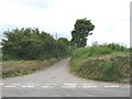
Junction of a minor road with the B 4419
Image: © Eric Jones
Taken: 13 Jun 2008
0.21 miles
7
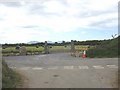
New entrance and driveway through a meadow with baled silage
This new farm entrance and driveway is not marked on any map.
Image: © Eric Jones
Taken: 13 Jun 2008
0.23 miles
8
Fron Heulog Farm
Track opposite leads to Gelliniog
Image: © John Firth
Taken: 8 Oct 2010
0.23 miles
10
Gelliniog-ddu farm road and Fron Heulog
Image: © Eric Jones
Taken: 13 Jun 2008
0.24 miles