IMAGES TAKEN NEAR TO
Brynsiencyn, LLANFAIRPWLLGWYNGYLL, LL61 6SZ
Introduction
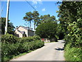
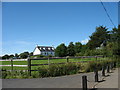
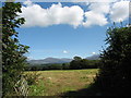
This page details the photographs taken nearby to LL61 6SZ by members of the Geograph project.
The Geograph project started in 2005 with the aim of publishing, organising and preserving representative images for every square kilometre of Great Britain, Ireland and the Isle of Man.

There are currently over 7.5m images from over14,400 individuals and you can help contribute to the project by visiting https://www.geograph.org.uk
Image Map
Images are licensed for reuse under creativecommons.org/licenses/by-sa/2.0
Notes
- Clicking on the map will re-center to the selected point.
- The higher the marker number, the further away the image location is from the centre of the postcode.
Image Listing (5 Images Found)
Images are licensed for reuse under creativecommons.org/licenses/by-sa/2.0
Image
Details
Distance
4
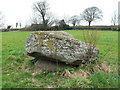
The Cromlech, Brynsiencyn, Isle of Anglesey.
A view of the ancient cromlech.
Image: © Stephen Elwyn RODDICK
Taken: 30 Mar 2006
0.23 miles
5
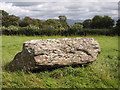
Brynsiencyn Burial Chamber
Also known as the Perthi-duon burial chamber. Opinion varies on whether this is a prehistoric structure.
Image: © Chris Andrews
Taken: 17 Aug 2014
0.25 miles