IMAGES TAKEN NEAR TO
Chapel Street, LLANFAIRPWLLGWYNGYLL, LL61 6RU
Introduction
This page details the photographs taken nearby to Chapel Street, LL61 6RU by members of the Geograph project.
The Geograph project started in 2005 with the aim of publishing, organising and preserving representative images for every square kilometre of Great Britain, Ireland and the Isle of Man.

There are currently over 7.5m images from over14,400 individuals and you can help contribute to the project by visiting https://www.geograph.org.uk
Image Map
Images are licensed for reuse under creativecommons.org/licenses/by-sa/2.0
Notes
- Clicking on the map will re-center to the selected point.
- The higher the marker number, the further away the image location is from the centre of the postcode.
Image Listing (30 Images Found)
Images are licensed for reuse under creativecommons.org/licenses/by-sa/2.0
Image
Details
Distance
7
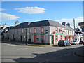
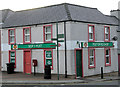
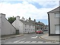
"Sgwar" Niwbwrch - Newborough "Square"
The area around these crossroads is referred to locally as "Y Sgwar". The building with the patriotic colour scheme is Siop y Post - the Post Office Shop.
Image: © Eric Jones
Taken: 7 Jun 2008
0.05 miles
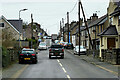
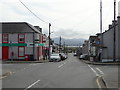
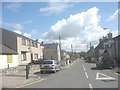
10
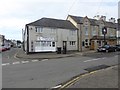
Centre of Newborough village
"Twinkle Toes", chiropody clinic, stands next to the "White Lion".
Image: © Oliver Dixon
Taken: 7 Apr 2016
0.06 miles