IMAGES TAKEN NEAR TO
Ffordd Brynsiencyn, LLANFAIRPWLLGWYNGYLL, LL61 6PF
Introduction
This page details the photographs taken nearby to Ffordd Brynsiencyn, LL61 6PF by members of the Geograph project.
The Geograph project started in 2005 with the aim of publishing, organising and preserving representative images for every square kilometre of Great Britain, Ireland and the Isle of Man.

There are currently over 7.5m images from over14,400 individuals and you can help contribute to the project by visiting https://www.geograph.org.uk
Image Map
Images are licensed for reuse under creativecommons.org/licenses/by-sa/2.0
Notes
- Clicking on the map will re-center to the selected point.
- The higher the marker number, the further away the image location is from the centre of the postcode.
Image Listing (16 Images Found)
Images are licensed for reuse under creativecommons.org/licenses/by-sa/2.0
Image
Details
Distance
1
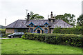
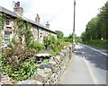
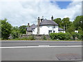
Victoria Cottages
Pair of cottages, built around 1833 as a school. Grade II listed - see http://cadwpublic-api.azurewebsites.net/reports/listedbuilding/FullReport?lang=en&id=5467 and http://cadwpublic-api.azurewebsites.net/reports/listedbuilding/FullReport?lang=en&id=19672 for the two parts.
Image: © Ian Capper
Taken: 23 Sep 2013
0.00 miles
2
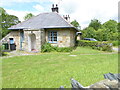
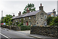
Victoria Cottages
Built c1833 as a school house, on land provided by the Rev. Henry Rowlands of Plas Gwyn and with a donation of £80 from the Duchess of Kent on her visit to the Beaumaris Eisteddfod in 1832. Named after Queen Victoria who planted a tree in the grounds during one of her visits to the Island. Grade II listed.
Image: © Eirian Evans
Taken: 21 Jun 2015
0.01 miles
3
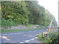
Road junction at Victoria Cottages
Looking south west along A4080
Image: © John Firth
Taken: 8 Oct 2010
0.02 miles
5
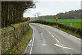
Tyddyn Pwyth Cottages
Located on NW side of the A4080 Brynsiencyn Road, opposite the walls of Plas Newydd. Originally these cottages were a farm called 'Ty Hir', with longhouse plan, the original house bing at the right end with cowhouse to left. The building was converted into three terraced cottages mid C19 and formed part of the Plas Newydd Estate. They are Grade II listed.
Image: © Eirian Evans
Taken: 21 Jun 2015
0.10 miles
6
Tyddyn-pwyth
Mid 19th century terrace converted from a former farmhouse (at this end). The three sections are grade II listed - see (from right to left) http://cadwpublic-api.azurewebsites.net/reports/listedbuilding/FullReport?lang=en&id=5466, http://cadwpublic-api.azurewebsites.net/reports/listedbuilding/FullReport?lang=en&id=19670 and http://cadwpublic-api.azurewebsites.net/reports/listedbuilding/FullReport?lang=en&id=19671.
Image: © Ian Capper
Taken: 23 Sep 2013
0.10 miles
7
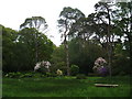
A glade in the Rhododendron Gardens, Plas Newydd
Image: © Peter Barr
Taken: 5 May 2009
0.18 miles
8
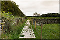
Alongside Brynsiencyn Road
A recently built off-road section of the Anglesey Coastal Path alongside Brynsiencyn Road, with a boardwalk over this damp area.
Image: © Ian Capper
Taken: 23 Sep 2013
0.20 miles
9
Pen-yr-Allt, near Llanfair PG
Originally a farmhouse built in the mid 19th century. It was later rebuilt and served as the home of the head forester of the Plas Newydd Estate. Grade II listed. It is located on the Brynsiencyn Road, opposite the entrance to Plas Newydd.
Image: © Eirian Evans
Taken: 21 Jun 2015
0.21 miles
10
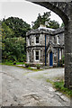
Grand Lodge
Originally the main lodge to Plas Newydd. Built in the mid 19th century and grade II listed - see http://cadwpublic-api.azurewebsites.net/reports/listedbuilding/FullReport?lang=en&id=5458.
Image: © Ian Capper
Taken: 23 Sep 2013
0.22 miles