IMAGES TAKEN NEAR TO
Ffordd Caergybi, LLANFAIRPWLLGWYNGYLL, LL61 5SZ
Introduction
This page details the photographs taken nearby to Ffordd Caergybi, LL61 5SZ by members of the Geograph project.
The Geograph project started in 2005 with the aim of publishing, organising and preserving representative images for every square kilometre of Great Britain, Ireland and the Isle of Man.

There are currently over 7.5m images from over14,400 individuals and you can help contribute to the project by visiting https://www.geograph.org.uk
Image Map
Images are licensed for reuse under creativecommons.org/licenses/by-sa/2.0
Notes
- Clicking on the map will re-center to the selected point.
- The higher the marker number, the further away the image location is from the centre of the postcode.
Image Listing (300 Images Found)
Images are licensed for reuse under creativecommons.org/licenses/by-sa/2.0
Image
Details
Distance
1
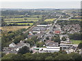
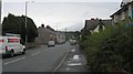
Llanfairpwllgwyngyll: view over the town centre
Looking from the top of Image along the main Holyhead Road, the A5, as it runs parallel with the railway on the way to Holyhead. The station is most easily identifiable by the footbridge, just beyond which is the James Pringle shop, the destination for most tourists arriving for the long name of the town, Llanfairpwllgwyngyllgogerychwyrndrobwllllantysiliogogogoch.
Image: © Chris Downer
Taken: 10 Aug 2013
0.02 miles
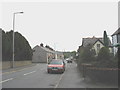
3
Holyhead Road bungalows, Llanfairpwllgwyngyll
On the north side of the A5 Holyhead Road.
Image: © Jaggery
Taken: 26 Mar 2012
0.03 miles
4
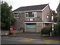
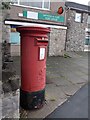
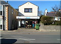
Llanfairpwllgwyngyll: the post office
Leaving aside the famous full length version of the name, which is really a fanciful embellishment, the official version Llanfairpwllgwyngyll is worth looking at. On modern-day maps, the name of the parish is given as two words, Llanfair Pwllgwyngyll, while it was one word (slightly differently spelt as Llanfairpwllgwingyll) according to the GPO in 1857 to at least 1867. The GPO had changed the official name to Llanfairpwll (with "or Llanfairpwllgwyngyll" appended) certainly by 1907. The reversion to Llanfairpwllgwyngyll was noted in the PO Gazette on 23 June 1971 and this has been the correct postal address ever since.
There has been a post office in the town since 28 June 1845 when it was called Bryn Llanfair. The office was renamed Llanfairpwllgwingyll (see above) about ten years later.
It has been a post town since 1 August 1905.
Image: © Chris Downer
Taken: 13 Aug 2013
0.04 miles
5
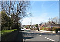
View East along the A5 at Llanfairpwllgwyngyll
Image: © Eric Jones
Taken: 29 Jul 2009
0.04 miles
6
Llanfairpwllgwyngyll: postbox № LL61 27, Ffordd Caergybi
This large, Elizabeth II-reign postbox stands outside Image on Ffordd Caergybi (Holyhead Road) and is emptied finally at 5:30pm on weekdays and at 11:30am on Saturdays.
Image: © Chris Downer
Taken: 13 Aug 2013
0.04 miles
8
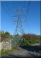
Electricity pylon on the east side of Station Road, Llanfairpwll
The power lines here run parallel with the south side of the North Wales Coast Line railway.
Image: © Jaggery
Taken: 26 Mar 2012
0.05 miles
9
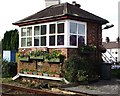
A well decorated signal box!
Llanfair P.G. crossing box. Originally a signal box until 1973 but nowadays classified as a crossing box as the whole area is controlled from Bangor but the crossing keeper is still manning the gates under Bangor signal box authority. Opened in 1871, it's the last remaining all brick design built by the Chester & Holyhead Railway. The box is not classified as listed and new windows were put in 2003 to replace smaller pane style windows. In 2000 it won the best kept crossing box in the North West Zone of Railtrack with thanks to the crossing keepers on duty attending to window boxes and the rest of the floral display.
Image: © Alan Roberts
Taken: 7 Mar 2014
0.05 miles
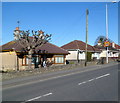
10
Hospice at Home charity shop, Llanfairpwllgwyngyll
On the north side of the A5 Holyhead Road, near the post office.
Image: © Jaggery
Taken: 26 Mar 2012
0.05 miles