IMAGES TAKEN NEAR TO
LLANFAIRPWLLGWYNGYLL, LL61 5RZ
Introduction
This page details the photographs taken nearby to LL61 5RZ by members of the Geograph project.
The Geograph project started in 2005 with the aim of publishing, organising and preserving representative images for every square kilometre of Great Britain, Ireland and the Isle of Man.

There are currently over 7.5m images from over14,400 individuals and you can help contribute to the project by visiting https://www.geograph.org.uk
Image Map
Images are licensed for reuse under creativecommons.org/licenses/by-sa/2.0
Notes
- Clicking on the map will re-center to the selected point.
- The higher the marker number, the further away the image location is from the centre of the postcode.
Image Listing (88 Images Found)
Images are licensed for reuse under creativecommons.org/licenses/by-sa/2.0
Image
Details
Distance
1
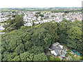
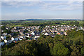
Llanfairpwllgwyngyll: view over the suburbs
I'm not sure if the town is big enough for this to be described as the suburbs, but anyway this is the view across the housing to the northeast of the town, from the top of Image Column Cottage, whose owners are responsible for the upkeep of the column, is in the foreground.
Image: © Chris Downer
Taken: 10 Aug 2013
0.03 miles
2
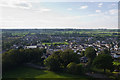
![Llanfair Pwllgwyngyll roofscape [1]](https://s3.geograph.org.uk/geophotos/01/05/83/1058331_a17ecffe_120x120.jpg)
Llanfair Pwllgwyngyll roofscape [1]
The view NNW from the Marquess of Anglesey's Column. http://www.geograph.org.uk/photo/786189
Just beyond the houses, the route of the A55 can be made out by following the lampposts.
Image: © Robin Drayton
Taken: 15 Aug 2008
0.04 miles
3
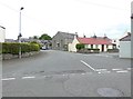
Lon Foel Graig, Llanfair P G
Ebeneser Independent Chapel was first built in 1805 and then rebuilt in 1839 in the Vernacular style of the gable-entry type.
Image: © Eirian Evans
Taken: 21 Jun 2015
0.09 miles
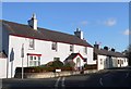
5
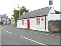
Pen Parc, Llanfair P G
Grade II listed as a relatively unaltered crogloft cottage, retaining much of its original character as a small vernacular building, and predating most of the houses in the village which developed after the railway was built in 1848. Sited at the top of a hill, on SE side of Lon Pant, immediately on the roadside opposite the junction with Lon Foel Graig.
Image: © Eirian Evans
Taken: 21 Jun 2015
0.11 miles
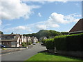
6
Lon Dryll
Road on the large estate on the north side of Llanfairpwll, viewed from the Marquess of Anglesey's Column.
Image: © Ian Capper
Taken: 29 Sep 2013
0.11 miles
7
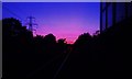
Glorious sunset.
Sunset from the level crossing at Llanfair P.G. Taken before daylight disappeared April 2015
Image: © Alan Roberts
Taken: 10 Apr 2015
0.12 miles
8
Llanfairpwll
Llanfairpwll from the Marquess of Anglesey's Column. On the left is the railway and the A5, both leading towards Holyhead, with part of the more modern estate that now makes up most of the village on the right.
Image: © Ian Capper
Taken: 29 Sep 2013
0.12 miles
9
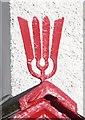
Eel Catching Spear
A detail of the old eel catching spear converted into a finial.
Image: © Stephen Elwyn RODDICK
Taken: 25 Jan 2006
0.14 miles
10
Lon Pant, Llanfairpwllgwyngyll.
A view of Lôn Pant, Llanfairpwllgwyngyll. The finial above the house porch is very unusual!
Image: © Stephen Elwyn RODDICK
Taken: 25 Jan 2006
0.14 miles