IMAGES TAKEN NEAR TO
Ffordd Penmynydd, LLANFAIRPWLLGWYNGYLL, LL61 5EX
Introduction
This page details the photographs taken nearby to Ffordd Penmynydd, LL61 5EX by members of the Geograph project.
The Geograph project started in 2005 with the aim of publishing, organising and preserving representative images for every square kilometre of Great Britain, Ireland and the Isle of Man.

There are currently over 7.5m images from over14,400 individuals and you can help contribute to the project by visiting https://www.geograph.org.uk
Image Map
Images are licensed for reuse under creativecommons.org/licenses/by-sa/2.0
Notes
- Clicking on the map will re-center to the selected point.
- The higher the marker number, the further away the image location is from the centre of the postcode.
Image Listing (32 Images Found)
Images are licensed for reuse under creativecommons.org/licenses/by-sa/2.0
Image
Details
Distance
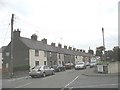
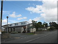
3
Plas Garnedd Residential Home, Llanfairpwll
http://www.plasgarnedd.co.uk/
Image: © Eric Jones
Taken: 5 Aug 2009
0.07 miles
4
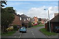
Collen Wen Estate, Llanfairpwll
Collen Wen means "white hazel".
Image: © Eric Jones
Taken: 5 Aug 2009
0.07 miles
5
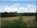
Public footpath leading from the Garnedd estate towards the A55
Image: © Eric Jones
Taken: 5 Aug 2009
0.07 miles
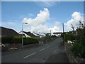
7
Lon y Wylan, Llanfairpwll
Lon y Wylan (=gull's lane) leads off Lon Penmynydd.
Image: © Eric Jones
Taken: 5 Aug 2009
0.09 miles
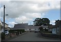
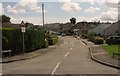
8

View WSW along Lon Penmynydd, Llanfairpwll
Image: © Eric Jones
Taken: 5 Aug 2009
0.09 miles
10
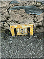
Partially buried Hydrant marker on Trem Eryri, Llanfairpwllgwyngyll
Image: © Meirion
Taken: 11 Nov 2021
0.13 miles