IMAGES TAKEN NEAR TO
Pentre Berw, GAERWEN, LL60 6HU
Introduction
This page details the photographs taken nearby to LL60 6HU by members of the Geograph project.
The Geograph project started in 2005 with the aim of publishing, organising and preserving representative images for every square kilometre of Great Britain, Ireland and the Isle of Man.

There are currently over 7.5m images from over14,400 individuals and you can help contribute to the project by visiting https://www.geograph.org.uk
Image Map
Images are licensed for reuse under creativecommons.org/licenses/by-sa/2.0
Notes
- Clicking on the map will re-center to the selected point.
- The higher the marker number, the further away the image location is from the centre of the postcode.
Image Listing (27 Images Found)
Images are licensed for reuse under creativecommons.org/licenses/by-sa/2.0
Image
Details
Distance
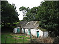
1
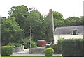
An industrial relic at the bottom of the garden
This chimney probably belonged to a lime kiln.
Image: © Eric Jones
Taken: 1 Aug 2007
0.03 miles
2
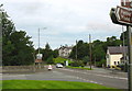
Junction of the B4419 from Newborough with the A5 at Pentre Berw
Image: © Eric Jones
Taken: 1 Aug 2007
0.04 miles
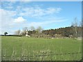
4
Old farm buildings alongside the A5 at Pentre Berw
Image: © Eric Jones
Taken: 1 Aug 2007
0.07 miles
5
House near the woodlands between Pentre Berw and Gaerwen
Image: © Eric Jones
Taken: 14 Apr 2008
0.08 miles
6
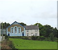
Capel Berea (Annibynwyr/Independents) and chapel house
Image: © Eric Jones
Taken: 1 Aug 2007
0.09 miles
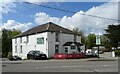
7
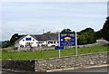
Tafarn y Gors - a Free House on the Mornest Caravan Park
Image: © Eric Jones
Taken: 1 Aug 2007
0.09 miles
8
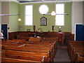
Berea Independent Church, Pentre Berw, Anglesey
Interior of Eglwys Berea, Pentre Berw, opened in 1839.
Image: © John Robertson
Taken: 8 Jun 2005
0.11 miles
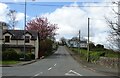
9
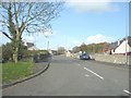
Minor road leading north from the A5 at Pentre Berw
Image: © Eric Jones
Taken: 23 Apr 2008
0.12 miles