IMAGES TAKEN NEAR TO
Stad Cynlas, GAERWEN, LL60 6DQ
Introduction
This page details the photographs taken nearby to Stad Cynlas, LL60 6DQ by members of the Geograph project.
The Geograph project started in 2005 with the aim of publishing, organising and preserving representative images for every square kilometre of Great Britain, Ireland and the Isle of Man.

There are currently over 7.5m images from over14,400 individuals and you can help contribute to the project by visiting https://www.geograph.org.uk
Image Map
Images are licensed for reuse under creativecommons.org/licenses/by-sa/2.0
Notes
- Clicking on the map will re-center to the selected point.
- The higher the marker number, the further away the image location is from the centre of the postcode.
Image Listing (31 Images Found)
Images are licensed for reuse under creativecommons.org/licenses/by-sa/2.0
Image
Details
Distance
1
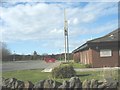
The worshippers' car park at the Gaerwen chapel of the Latter-Day Saints
The plate on the side of the building shows it to be a chapel of Eglwys Iesu Grist Saint y Dyddiau Diwethaf (Church of Jesus Christ of the Latter Day Saints)
http://www.lds.org.uk/chapel_locator_details.php?id=77
Image: © Eric Jones
Taken: 14 Apr 2008
0.02 miles
2
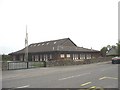
Capel y Mormoniaid Gaerwen Mormon Chapel
This modern style chapel dates back to 1985. In the early days of Mormonism, Wales had a number of congregations. Many of the pioneer Mormons migrated to Utah. In fact, today, in the state of Utah, half a million people, a fifth of the total population, claim Welsh ancestry.
http://www.welshmormonhistory.org/
Image: © Eric Jones
Taken: 16 May 2008
0.03 miles
4
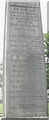
Names of the fallen inscribed on the Gaerwen War Memorial
The line at the bottom is a quote from Hen Wlad Fy Nhadau - the Welsh National Anthem - and be translated thus:
"For Freedom they shed their blood".
Image: © Eric Jones
Taken: 16 May 2008
0.08 miles
5
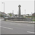
The Gaerwen War Memorial
This takes the form of an inscribed Celtic cross.
Image: © Eric Jones
Taken: 16 May 2008
0.08 miles
6
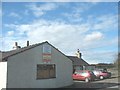
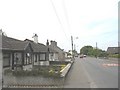
The disused Fron Bakery now on sale for residential development
Image: © Eric Jones
Taken: 14 Apr 2008
0.10 miles
7
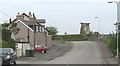
Approaching the ruined Pentre Berw Windmill
This mill is also marked on 19th century maps as Union Mill.
Image
Image: © Eric Jones
Taken: 16 May 2008
0.13 miles
8
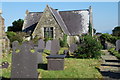
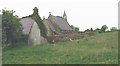
Mynwent Eglwys S Mihangel Gaerwen St Michael's Churchyard
The churchyard of Image
The derelict buildings lie at the end of the churchyard and to the rear of the new rectory.
Image: © Alan Fryer
Taken: 6 Oct 2007
0.13 miles
9
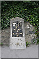
Old Milestone by the A5 in Gaerwen, Ynys M?n
Telford Plate by the A5, in parish of Llanfihangel Ysgeifiog (Anglesey District), Gaerwen; Catwys St Mihangel.
Inscription reads:-
HOLY-
HEAD
17
MONA
4
BANGOR
8
Grade II listed by Cadw.
Reference Number: 20613 https://cadwpublic-api.azurewebsites.net/reports/listedbuilding/FullReport?lang=&id=20613
Surveyed
Milestone Society National ID: ANG_HH17
Image: © Milestone Society
Taken: Unknown
0.13 miles
10
The old school master's house at the Gaerwen National School
The house, part of the school complex, is situated overlooking the cemetery of Eglwys St Mihangel. National schools were Anglican foundations and were bitterly opposed by the Welsh Nonconformist establishment who set up their own British Schools. Gaerwen also had a British School.
Image: © Eric Jones
Taken: 16 May 2008
0.14 miles