IMAGES TAKEN NEAR TO
Lon Groes, GAERWEN, LL60 6DF
Introduction
This page details the photographs taken nearby to Lon Groes, LL60 6DF by members of the Geograph project.
The Geograph project started in 2005 with the aim of publishing, organising and preserving representative images for every square kilometre of Great Britain, Ireland and the Isle of Man.

There are currently over 7.5m images from over14,400 individuals and you can help contribute to the project by visiting https://www.geograph.org.uk
Image Map
Images are licensed for reuse under creativecommons.org/licenses/by-sa/2.0
Notes
- Clicking on the map will re-center to the selected point.
- The higher the marker number, the further away the image location is from the centre of the postcode.
Image Listing (4 Images Found)
Images are licensed for reuse under creativecommons.org/licenses/by-sa/2.0
Image
Details
Distance
1
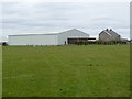
Farming store at Gaerwen
Store of Clynderwen and Cardiganshire Farmers, seen from the junction of Lon Groes and Chapel Street.
Image: © Oliver Dixon
Taken: 8 Apr 2016
0.17 miles
2
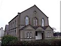
Chapel in Gaerwen
Chapel in chapel street, Gaerwen
Image: © Nigel Williams
Taken: 11 Feb 2006
0.20 miles
3
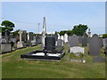
Chapel cemetery, Gaerwen
Off Chapel Street.
Image: © Eirian Evans
Taken: 21 May 2010
0.21 miles