IMAGES TAKEN NEAR TO
Star, GAERWEN, LL60 6AY
Introduction
This page details the photographs taken nearby to LL60 6AY by members of the Geograph project.
The Geograph project started in 2005 with the aim of publishing, organising and preserving representative images for every square kilometre of Great Britain, Ireland and the Isle of Man.

There are currently over 7.5m images from over14,400 individuals and you can help contribute to the project by visiting https://www.geograph.org.uk
Image Map
Images are licensed for reuse under creativecommons.org/licenses/by-sa/2.0
Notes
- Clicking on the map will re-center to the selected point.
- The higher the marker number, the further away the image location is from the centre of the postcode.
Image Listing (30 Images Found)
Images are licensed for reuse under creativecommons.org/licenses/by-sa/2.0
Image
Details
Distance
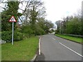
1
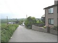
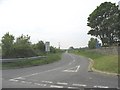
The main street of Star
This leads down hill and across the A55 to join the A5.
Image: © Eric Jones
Taken: 16 May 2008
0.01 miles
2
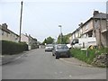
Bryn Ffynnon - a local authority built estate
Image: © Eric Jones
Taken: 16 May 2008
0.03 miles
3
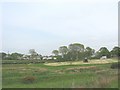
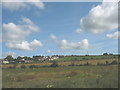
View north-eastwards across fields to the hamlet of Star
Image: © Eric Jones
Taken: 16 May 2008
0.05 miles
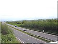
6
View across the A55 (hidden) and fields towards the village of Star
The A55 here runs through a cutting
Image: © Eric Jones
Taken: 14 Apr 2008
0.07 miles
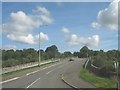
7
View east along the A55 from the Star over bridge
Image: © Eric Jones
Taken: 16 May 2008
0.11 miles
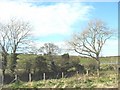
8
Entrance to the new access lane leading to Garnedd Ddu and Garnedd Isaf
Image: © Eric Jones
Taken: 16 May 2008
0.13 miles
9
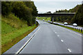
Bridge over the North Wales Expressway, west of Llanfairpwllgwyngyll
Image: © David Dixon
Taken: 24 Sep 2017
0.13 miles