IMAGES TAKEN NEAR TO
Llansadwrn, MENAI BRIDGE, LL59 5SR
Introduction
This page details the photographs taken nearby to LL59 5SR by members of the Geograph project.
The Geograph project started in 2005 with the aim of publishing, organising and preserving representative images for every square kilometre of Great Britain, Ireland and the Isle of Man.

There are currently over 7.5m images from over14,400 individuals and you can help contribute to the project by visiting https://www.geograph.org.uk
Image Map
Images are licensed for reuse under creativecommons.org/licenses/by-sa/2.0
Notes
- Clicking on the map will re-center to the selected point.
- The higher the marker number, the further away the image location is from the centre of the postcode.
Image Listing (13 Images Found)
Images are licensed for reuse under creativecommons.org/licenses/by-sa/2.0
Image
Details
Distance
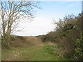
1
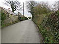
Road between Llanddona and the B5109 at Rhos Uchaf
Looking south-westward.
Image: © Peter Wood
Taken: 2 Dec 2017
0.02 miles
2
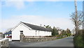
Cottages next to the former Penucheldre Chapel
Image: © Eric Jones
Taken: 5 Apr 2007
0.08 miles
3
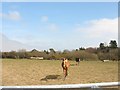
Horses in a field next to the Hafoty Covert
Image: © Eric Jones
Taken: 5 Apr 2007
0.10 miles
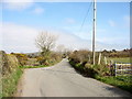
4
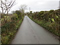
Road between the B5109 and Llanddona
Looking north-eastward towards Hafoty
Image: © Peter Wood
Taken: 2 Dec 2017
0.12 miles
5
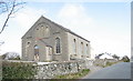
Capel Penucheldref
This Calvinistic Methodist chapel is about a quarter of a mile from the village of Llansadwrn. The present building dates from the 1870s, but was enlarged following the Revival of 1904-05. The chapel also had a library. It closed in 1997 and put on the market.
Image: © Eric Jones
Taken: 5 Apr 2007
0.12 miles
7
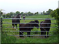
Horses and Ponies in a field
View from the roadside of two horses and two ponies by the gate into a field
Image: © Nigel Williams
Taken: 13 May 2006
0.19 miles
8
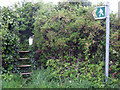
Overgrown stile
An overgrown stile alongside the road, it is still passable, as the steps are clear of vegetation
Image: © Nigel Williams
Taken: 13 May 2006
0.19 miles
10
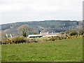
Rhiwiau Farm with Mynydd Llwydiarth in the background
Image: © Eric Jones
Taken: 5 Apr 2007
0.21 miles