IMAGES TAKEN NEAR TO
Lon Ty Newydd, MENAI BRIDGE, LL59 5RB
Introduction
This page details the photographs taken nearby to Lon Ty Newydd, LL59 5RB by members of the Geograph project.
The Geograph project started in 2005 with the aim of publishing, organising and preserving representative images for every square kilometre of Great Britain, Ireland and the Isle of Man.

There are currently over 7.5m images from over14,400 individuals and you can help contribute to the project by visiting https://www.geograph.org.uk
Image Map
Images are licensed for reuse under creativecommons.org/licenses/by-sa/2.0
Notes
- Clicking on the map will re-center to the selected point.
- The higher the marker number, the further away the image location is from the centre of the postcode.
Image Listing (32 Images Found)
Images are licensed for reuse under creativecommons.org/licenses/by-sa/2.0
Image
Details
Distance
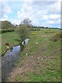
2
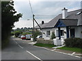
Tan-y-fynwent cottage
Tan-y-fynwent means "below the cemetery". The house stands next to St Tegfan church and cemetery.
Image: © Eric Jones
Taken: 30 Aug 2008
0.10 miles
3
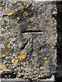
Benchmark at Eglwys Sant Tegfan, Llandegfan
This benchmark is located on the SE face of the tower at Eglwys Sant Tegfan in Llandegfan and it is shown in the current Ordnance Survey database at a height of 83.2711m above the Newlyn datum.
Image: © Meirion
Taken: 11 May 2012
0.12 miles
4
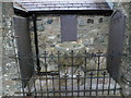
14th century font in the churchyard of Eglwys Sant Tegfan, Llandegfan
Unearthed during renovation in 1901/02.
Image: © Meirion
Taken: 11 May 2012
0.12 miles
6
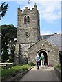
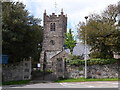
Eglwys St Tegfan, Llandegfan
The tower of St Tegfan dates back to 1811, having been paid for by the Hon. Thomas Bulkeley of Baron Hill. The nave and chancel, however, are much older.
Image: © Eric Jones
Taken: 30 Aug 2008
0.13 miles
7
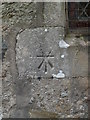
Cancelled benchmark at Eglwys Sant Tegfan, Llandegfan
This cancelled benchmark is located just under a window on the SE face of Eglwys Sant Tegfan in Llandegfan. The mark is not shown in the current Ordnance Survey database but is shown on an 1890 map of the area as being 276.9ft. above the Liverpool datum.
Image: © Meirion
Taken: 11 May 2012
0.13 miles
8
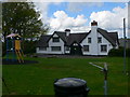
Llandegfan Parish Hall
The Parish Hall was donated to the village by the Rathbone Family for the benefit of the people in 1904, along with the site next to it so that it could be developed as recreational ground. Originally intended as a reading room and a lending library, it could also be used for choir practices, drama and cookery classes. Today The Parish Hall is used in much the same way as it was in the early years. In addition to concerts and plays, the annual Llandegfan Crown Eisteddfod is held there. Societies such as the Youth Club, Cultural Society, Merched y Wawr, Women's Institute and the Senior Citizen Club hold their meeting within its walls and it is also used as a doctor's surgery and as a polling booth during election times.
Image: © Eirian Evans
Taken: 4 May 2008
0.13 miles
10
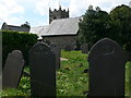
Churchyard, Llandegfan
Mostly slate gravestones in the churchyard, and I was surprised at how many of them had verses on them.
Image: © Eirian Evans
Taken: 2 May 2008
0.14 miles