IMAGES TAKEN NEAR TO
Lon Ty'N Y Caeau, MENAI BRIDGE, LL59 5LA
Introduction
This page details the photographs taken nearby to Lon Ty'N Y Caeau, LL59 5LA by members of the Geograph project.
The Geograph project started in 2005 with the aim of publishing, organising and preserving representative images for every square kilometre of Great Britain, Ireland and the Isle of Man.

There are currently over 7.5m images from over14,400 individuals and you can help contribute to the project by visiting https://www.geograph.org.uk
Image Map
Images are licensed for reuse under creativecommons.org/licenses/by-sa/2.0
Notes
- Clicking on the map will re-center to the selected point.
- The higher the marker number, the further away the image location is from the centre of the postcode.
Image Listing (30 Images Found)
Images are licensed for reuse under creativecommons.org/licenses/by-sa/2.0
Image
Details
Distance
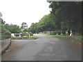
1
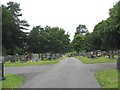
Western section of the Menai Bridge Cemetery
Image: © Eric Jones
Taken: 28 Jun 2008
0.07 miles
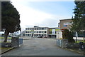
6
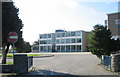
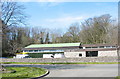
Ysgol David Hughes, Menai Bridge
The school was opened as a purpose built comprehensive school in 1963. It traces its origin to the Beaumaris Free Grammar School, established by David Hughes in 1603. The school serves a wide area of southern Anglesey. http://www.davidhughes.anglesey.sch.uk
Image: © Eric Jones
Taken: 7 Oct 2006
0.09 miles
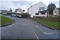
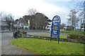
10
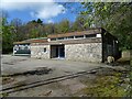
Telephone exchange on Ffordd Caergybi (Holyhead Road)
Image: © JThomas
Taken: 16 Apr 2024
0.14 miles