IMAGES TAKEN NEAR TO
Beach Road, MENAI BRIDGE, LL59 5HD
Introduction
This page details the photographs taken nearby to Beach Road, LL59 5HD by members of the Geograph project.
The Geograph project started in 2005 with the aim of publishing, organising and preserving representative images for every square kilometre of Great Britain, Ireland and the Isle of Man.

There are currently over 7.5m images from over14,400 individuals and you can help contribute to the project by visiting https://www.geograph.org.uk
Image Map
Images are licensed for reuse under creativecommons.org/licenses/by-sa/2.0
Notes
- Clicking on the map will re-center to the selected point.
- The higher the marker number, the further away the image location is from the centre of the postcode.
Image Listing (508 Images Found)
Images are licensed for reuse under creativecommons.org/licenses/by-sa/2.0
Image
Details
Distance
1
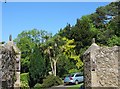
Ornamental trees in the gardens of Y Swellies house
Image: © Eric Jones
Taken: 29 May 2009
0.02 miles
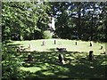
2
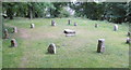
Stone Circle
This stone circle is just by the Menai Suspension Bridge.
Image: © Christine Courtney
Taken: 17 Jun 2008
0.02 miles
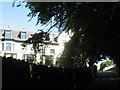
6

The George Bernard Shaw Garden at the Anglesey Arms Hotel
Image: © Eric Jones
Taken: 29 May 2009
0.03 miles
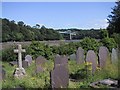
7
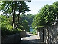
Cei Bont Lane
This lane turns east at the bend and passes beneath the arches of Pont y Borth.
Image: © Eric Jones
Taken: 29 May 2009
0.03 miles
8
Gwesty Anglesey Arms Hotel, Menai Bridge
Image: © Eric Jones
Taken: 29 May 2009
0.03 miles
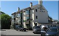
9
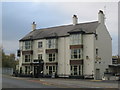
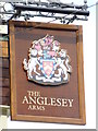
The Anglesey Arms
The building has been recently totally refurbished.
See also Image
Image: © Alan Fryer
Taken: 8 Nov 2011
0.04 miles