IMAGES TAKEN NEAR TO
Coronation Road, MENAI BRIDGE, LL59 5BD
Introduction
This page details the photographs taken nearby to Coronation Road, LL59 5BD by members of the Geograph project.
The Geograph project started in 2005 with the aim of publishing, organising and preserving representative images for every square kilometre of Great Britain, Ireland and the Isle of Man.

There are currently over 7.5m images from over14,400 individuals and you can help contribute to the project by visiting https://www.geograph.org.uk
Image Map
Images are licensed for reuse under creativecommons.org/licenses/by-sa/2.0
Notes
- Clicking on the map will re-center to the selected point.
- The higher the marker number, the further away the image location is from the centre of the postcode.
Image Listing (212 Images Found)
Images are licensed for reuse under creativecommons.org/licenses/by-sa/2.0
Image
Details
Distance
2
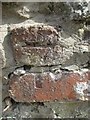
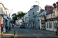
Damaged benchmark on Well Street, Menai Bridge
For more details see: https://www.bench-marks.org.uk/bm24179
Image: © Meirion
Taken: 30 Jul 2019
0.03 miles
3
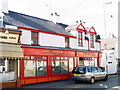
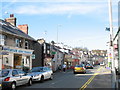
Blas ar India/Taste of India Restaurant, High Street
Image: © Eric Jones
Taken: 4 Apr 2007
0.04 miles
![High Street, Menai Bridge [1]](https://s1.geograph.org.uk/geophotos/01/48/06/1480689_037de1e8_120x120.jpg)