IMAGES TAKEN NEAR TO
Llanddona, BEAUMARIS, LL58 8UR
Introduction
This page details the photographs taken nearby to LL58 8UR by members of the Geograph project.
The Geograph project started in 2005 with the aim of publishing, organising and preserving representative images for every square kilometre of Great Britain, Ireland and the Isle of Man.

There are currently over 7.5m images from over14,400 individuals and you can help contribute to the project by visiting https://www.geograph.org.uk
Image Map
Images are licensed for reuse under creativecommons.org/licenses/by-sa/2.0
Notes
- Clicking on the map will re-center to the selected point.
- The higher the marker number, the further away the image location is from the centre of the postcode.
Image Listing (29 Images Found)
Images are licensed for reuse under creativecommons.org/licenses/by-sa/2.0
Image
Details
Distance
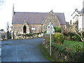
1
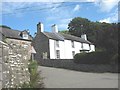
The former rectory viewed across Lon Goch from the lych gate of St Dona's Church
Image: © Eric Jones
Taken: 22 Aug 2008
0.09 miles
2
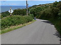
Allt Bron-philip
This is the very steep lane down to Red Wharf Bay.
Image: © Mat Fascione
Taken: 29 Jun 2011
0.11 miles
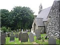
5

Benchmark on St Dona's Church, Llanddona
For more details see: https://www.bench-marks.org.uk/bm106863
Image: © Meirion
Taken: 22 Apr 2019
0.12 miles
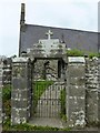
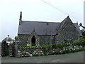
6
St Dona's church, Llanddona
For advice on access, see Image
Image: © David Purchase
Taken: 24 Dec 2018
0.12 miles
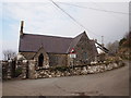
7
Church at Pentre Llwyn
The small church near to the beach at Pentre Llwyn
Image: © Nigel Williams
Taken: 13 May 2006
0.13 miles
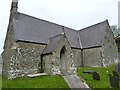
9
St Dona's Church, Llanddona
Re-built in the Gothic revival style in about 1873. It incorporates a fifteenth century door on the southern side.
Image: © Chris Andrews
Taken: 3 Mar 2018
0.13 miles
10
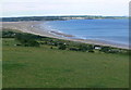
Red Wharf Bay
Viewed from high above the eastern end of the bay, along the extremely steep and narrow lane, Allt Bron-philip.
Image: © Mat Fascione
Taken: 26 Jun 2011
0.13 miles