IMAGES TAKEN NEAR TO
Llangoed, BEAUMARIS, LL58 8SS
Introduction
This page details the photographs taken nearby to LL58 8SS by members of the Geograph project.
The Geograph project started in 2005 with the aim of publishing, organising and preserving representative images for every square kilometre of Great Britain, Ireland and the Isle of Man.

There are currently over 7.5m images from over14,400 individuals and you can help contribute to the project by visiting https://www.geograph.org.uk
Image Map
Images are licensed for reuse under creativecommons.org/licenses/by-sa/2.0
Notes
- Clicking on the map will re-center to the selected point.
- The higher the marker number, the further away the image location is from the centre of the postcode.
Image Listing (23 Images Found)
Images are licensed for reuse under creativecommons.org/licenses/by-sa/2.0
Image
Details
Distance
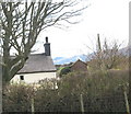
3
Plas Newydd, a cottage in north Anglesey
On the Anglesey Coastal Path, near Caim.
Image: © Peter Barr
Taken: 30 Apr 2011
0.06 miles
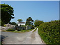
5
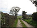
Junction of access lane with the Caim-Mariandyrys road
Image: © Eric Jones
Taken: 21 Mar 2007
0.10 miles
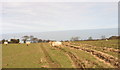
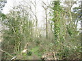
6
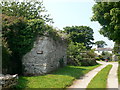
Overgrown limestone wall beside the Anglesey Coast Path
Image: © Eirian Evans
Taken: 5 Jul 2013
0.10 miles
7
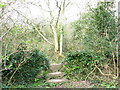
Stone stile and old village pump at the start of the Coed yr Hendy path
Image: © Eric Jones
Taken: 21 Mar 2007
0.14 miles
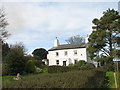
10
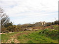
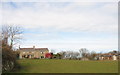
Cerrig Duon seen across the Plas Newydd conversion site
Image: © Eric Jones
Taken: 21 Mar 2007
0.17 miles