IMAGES TAKEN NEAR TO
Fryars Bay, BEAUMARIS, LL58 8RE
Introduction
This page details the photographs taken nearby to Fryars Bay, LL58 8RE by members of the Geograph project.
The Geograph project started in 2005 with the aim of publishing, organising and preserving representative images for every square kilometre of Great Britain, Ireland and the Isle of Man.

There are currently over 7.5m images from over14,400 individuals and you can help contribute to the project by visiting https://www.geograph.org.uk
Image Map
Images are licensed for reuse under creativecommons.org/licenses/by-sa/2.0
Notes
- Clicking on the map will re-center to the selected point.
- The higher the marker number, the further away the image location is from the centre of the postcode.
Image Listing (10 Images Found)
Images are licensed for reuse under creativecommons.org/licenses/by-sa/2.0
Image
Details
Distance
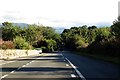
2

The B5109 road near Fryars Bay Anglesey
Image: © Steve Fareham
Taken: 12 Apr 2014
0.15 miles
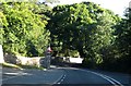

5
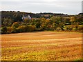
Fields Near Llanfaes
Henllys Hall in the distance.
Image: © Chris Andrews
Taken: 26 Oct 2014
0.24 miles
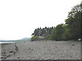
6
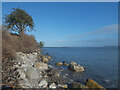
Dim llwybr ar lanw uchel / No path at high tide
Part of the Anglesey Coastal Path (at low tide).
Image: © Ceri Thomas
Taken: 22 Feb 2022
0.24 miles
7

Derelict Hangar on the Former Saunders Roe Site
Image: © Chris Andrews
Taken: 26 Oct 2014
0.24 miles
8
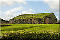
An abandoned industrial building at the Saunders Roe Beaumaris works
One of the four main buildings at the abandoned Saunders Roe facility, taken from the B5109 road near Fryars Bay. Note that the roof at the back of the second building (extreme left) has entirely collapsed.
Image: © Oliver Mills
Taken: 4 Jan 2022
0.24 miles
9
House on the beach at Fryars Road
The house, Gorad Bach, was located next to the old Beaumaris lifeboat station. A long metal jetty linked the lifeboat house to the shore. A steep launching ramp stood on the seaward side of the station. These are shown on the following link. These structures were demolished following the transfer of the station to Beaumaris town in the 1990s.
http://www.beaumarislifeboat.com/girlingnine.jpg
Image: © Eric Jones
Taken: 27 Apr 2007
0.25 miles
10
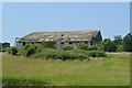
Former Saunders Roe Factory
Saunders Roe opened a factory at Fryars in 1943 to modify and fit out Catalina flying boats. Nearly 400 aircraft passed through the factory. A ramp onto the beach allowed testing to be carried out in the Menai Straits.
Image: © John M
Taken: 12 Jul 2013
0.25 miles