IMAGES TAKEN NEAR TO
Llangoed, BEAUMARIS, LL58 8PP
Introduction
This page details the photographs taken nearby to LL58 8PP by members of the Geograph project.
The Geograph project started in 2005 with the aim of publishing, organising and preserving representative images for every square kilometre of Great Britain, Ireland and the Isle of Man.

There are currently over 7.5m images from over14,400 individuals and you can help contribute to the project by visiting https://www.geograph.org.uk
Image Map
Images are licensed for reuse under creativecommons.org/licenses/by-sa/2.0
Notes
- Clicking on the map will re-center to the selected point.
- The higher the marker number, the further away the image location is from the centre of the postcode.
Image Listing (4 Images Found)
Images are licensed for reuse under creativecommons.org/licenses/by-sa/2.0
Image
Details
Distance
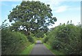
1
Road and track junction near Tan-y-coed
The track, which has public rights of way, links with paths leading westwards to the village of Llanddona.
Image: © Eric Jones
Taken: 22 Aug 2008
0.18 miles
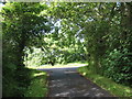
2
View south along the minor road to Llanfaes
The mountains of Snowdonia form the background.
Image: © Eric Jones
Taken: 22 Aug 2008
0.18 miles
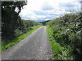
3
Approaching the junction with the Llangoed road
Image: © Eric Jones
Taken: 22 Aug 2008
0.19 miles