IMAGES TAKEN NEAR TO
Maes Hyfryd, BEAUMARIS, LL58 8HD
Introduction
This page details the photographs taken nearby to Maes Hyfryd, LL58 8HD by members of the Geograph project.
The Geograph project started in 2005 with the aim of publishing, organising and preserving representative images for every square kilometre of Great Britain, Ireland and the Isle of Man.

There are currently over 7.5m images from over14,400 individuals and you can help contribute to the project by visiting https://www.geograph.org.uk
Image Map
Images are licensed for reuse under creativecommons.org/licenses/by-sa/2.0
Notes
- Clicking on the map will re-center to the selected point.
- The higher the marker number, the further away the image location is from the centre of the postcode.
Image Listing (177 Images Found)
Images are licensed for reuse under creativecommons.org/licenses/by-sa/2.0
Image
Details
Distance
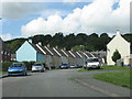
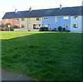
2
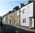
Ffordd Meigan houses, Beaumaris
Viewed from Maes Hyfryd.
Image: © Jaggery
Taken: 27 Mar 2012
0.03 miles
3
East side of Ffordd Meigan, Beaumaris
Viewed from Maes Hyfryd looking towards Bryn Teg.
Image: © Jaggery
Taken: 27 Mar 2012
0.06 miles
4
Wexham Street houses, Beaumaris
The trees on the left mark the end/start of houses on this (the northern) side of Wexham Street.
Image: © Jaggery
Taken: 27 Mar 2012
0.07 miles
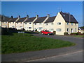
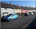
5
Houses on the south side of Maes Hyfryd, Beaumaris
The row of houses is set back 30 metres from the road.
Image: © Jaggery
Taken: 27 Mar 2012
0.07 miles
6
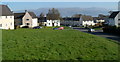
Houses in NW Beaumaris
Viewed from near the junction of Iscoed and Maes Hyfryd.
Image: © Jaggery
Taken: 27 Mar 2012
0.09 miles
7
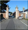
Grade II listed gate piers at SW end of Stanley Street, Beaumaris
Viewed from Maes Hyfryd. The gate piers, Grade II listed in September 1950, were originally part of the now-abandoned Baron Hill mansion.
Image: © Jaggery
Taken: 27 Mar 2012
0.10 miles
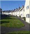
8
Maes Hyfryd, Beaumaris
Houses in Maes Hyfryd viewed from near the B5109 end.
Image: © Jaggery
Taken: 27 Mar 2012
0.11 miles
9
Wexham Street, Beaumaris
Houses on the north side of Wexham Street, at the northern edge of Beaumaris.
Image: © Jaggery
Taken: 27 Mar 2012
0.11 miles
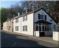
10
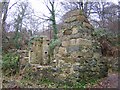
Britons Mills, Nant Meigan, Beaumaris.
Two water powered mills have stood at Nant Meigan since 1528. They are both clearly shown on John Speeds Map of Anglesey. The name derives from Sir Rowland Vielville, an illegitimate son of Henry VII who was brought up in Brittany and later became Constable of Beaumaris Castle. The corner stone is carved with the following inscription "RB 1675."
Image: © Stephen Elwyn RODDICK
Taken: 16 Jan 2006
0.11 miles