IMAGES TAKEN NEAR TO
Maes Hyfryd, BEAUMARIS, LL58 8EU
Introduction
This page details the photographs taken nearby to Maes Hyfryd, LL58 8EU by members of the Geograph project.
The Geograph project started in 2005 with the aim of publishing, organising and preserving representative images for every square kilometre of Great Britain, Ireland and the Isle of Man.

There are currently over 7.5m images from over14,400 individuals and you can help contribute to the project by visiting https://www.geograph.org.uk
Image Map
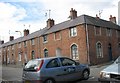
Images are licensed for reuse under creativecommons.org/licenses/by-sa/2.0
Notes
- Clicking on the map will re-center to the selected point.
- The higher the marker number, the further away the image location is from the centre of the postcode.
Image Listing (469 Images Found)
Images are licensed for reuse under creativecommons.org/licenses/by-sa/2.0
Image
Details
Distance
1
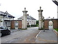
Ornate gate piers at the SW end of Stanley Street, Beaumaris
Image: © Meirion
Taken: 9 Sep 2011
0.02 miles
2
NE end of New Street, Beaumaris
Viewed from Steeple Lane looking along New Street towards Gaol Street.
Image: © Jaggery
Taken: 27 Mar 2012
0.02 miles
3
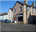
Gwalia Stores, Beaumaris
On the corner of New Street and Gaol Street.
Image: © Jaggery
Taken: 27 Mar 2012
0.02 miles
4
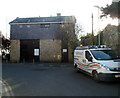
Beaumaris telephone exchange
The BT Openreach van is parked in Steeple Lane in front of the telephone exchange.
Openreach is the infrastructure division of the telecommunications company BT Group.
Image: © Jaggery
Taken: 27 Mar 2012
0.03 miles
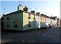
5
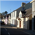
Steeple Lane houses, Beaumaris
Houses on the east side of Steeple Lane, viewed from the corner of Church Street.
Image: © Jaggery
Taken: 27 Mar 2012
0.03 miles
6
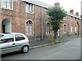
Church Street and Wexham Street houses near Steeple Lane, Beaumaris
The larger house, with the street name sign on the wall, is at 50 Church Street, facing the junction with Steeple Lane. The houses beyond are in Wexham Street.
Image: © Jaggery
Taken: 27 Mar 2012
0.04 miles
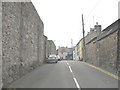
7
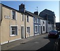
Stanley Street
This short street was built in the 1830s to house local workers. The architecture is based on a French design and the arched passageways between the houses are to permit coal to be carried to back-yard sheds without it having to pass through the houses.
Image: © James Allan
Taken: 5 Sep 2007
0.04 miles
8
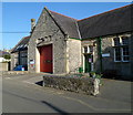
Beaumaris Fire Station
Located in New Street, part of North Wales Fire & Rescue Service.
Image: © Jaggery
Taken: 27 Mar 2012
0.04 miles
9
Stanley Street, Beaumaris
No 6 Stanley Street houses an artist's studio and exhibition centre.
http://www.allenstudio6.com/exhibitions.htm
Image: © Eric Jones
Taken: 22 Aug 2008
0.05 miles
10
The walls and main gate of Beaumaris Prison
Beaumaris Gaol was designed by Joseph Hansom, of "Hansom cab" fame and built in 1829. It was later expanded in 1867. It served as the jail for the whole of the Island of Anglesey. There were two executions at the gaol, those of William Griffith for the attempted murder of his wife and of Richard Rowlands (Dic Rolant) for the murder of his father in law. With his dying breath Dic cursed the clock of St Mary and St Nicholas Church. The prison was closed in 1878. It then served as the town's police station. It is now a museum.
http://www.galenfrysinger.com/wales_beaumaris_gaol.htm
Image: © Eric Jones
Taken: 8 Aug 2008
0.05 miles